The online Atlas of Historical County Boundaries is a go-to resource for determining old U.S. county boundaries. Its popular, interactive map will re-launch later this fall. Meanwhile, you can still access county boundary data and even Google Earth compatible maps.
For quite some time, the online U.S. Atlas of Historical County Boundaries has flashed the following message at the top of its webpage:
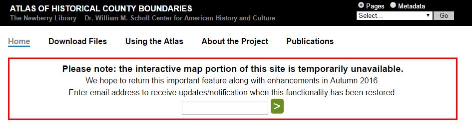
The first time I saw this message, I panicked. This is my favorite resource for quickly researching historical county boundaries in the U.S. The interactive map feature lets you click on a state and then on a county to see its boundaries on any exact date. I realized the rich data that feeds the interactive map is still there and you can still get to it.
Several months later, I noticed the out of order message was still there. I emailed the Newberry Library in Chicago which hosts the Atlas to see what they could share with Genealogy Gems about the Atlas and its future.
Curator Matt Rutherford replied right away: “We love Genealogy Gems! It’s such an excellent podcast.” (Lisa says “Thanks! We love you, too!”)
He explained that the online Atlas was originally meant to serve a small group of historians. When the interactive map’s code became outdated, the thought was to just let it die. He credits genealogists with giving it a future.
 “Newberry heard loudly and clearly from the genealogy community about their love for the online Atlas,” says Matt. “It is because of the popularity of the Atlas among genealogists and due to Newberry’s commitment to serving the genealogy community that [we’ve] decided to dedicate resources to the interactive map’s redevelopment.”
When will the interactive map be back? “We do anticipate a launch in the fall, but we don’t have an exact date yet,” he says. “It takes time and funding to redevelop an interactive tool that is as data-rich as the Atlas. Once we got ‘under the hood,’ we realized that the redevelopment needed to be more extensive than originally anticipated.” (Genealogy Gems Premium website members can hear the full scoop from Matt in the Genealogy Gems Premium Podcast episode #137.)
How to find county boundaries with the Atlas of Historical County Boundaries in three steps
1. From the Atlas home page, click on the state of interest from the national interactive map.
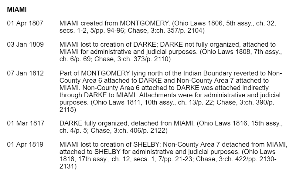
2. From the state page, click on View Index of Counties and Equivalents. This will show you all current and past county names. (See image.)
3. From this page, click on your targeted county. You’ll find a timeline of that county’s boundary changes.
Use the timeline to discover what county your ancestors belonged to at any given time. Perhaps you’ll discover you should actually be looking for an ancestor’s marriage record or  probate in a parent county, one that existed there before the current county, or in a successor county later carved out of this one.
Google Earth Bonus: The Atlas of Historical Boundary Changes state pages include downloadable maps compatible with Google Earth and Google Maps. If you are not using Google Earth for genealogy yet, watch Lisa Louise Cooke’s free video to see how and why you want to use this amazing 3D map of the world for your family history!
More Gems on Using Interactive Maps for Genealogy
Illuminating Time-Lapse Videos Show Our Changing World
Historical Maps of New York City and More Now Free Online
Family Maps and Migration Routes Traced with New Tech Tools


This tool puts the excellent Newberry Library historical county boundaries on top of Google Maps:
The Historical U.S. County Boundary Maps interactive tool ( http://randymajors.com/p/maps.html ) shows you the historical county boundaries for any place and historical date you’re researching. See details on when and how the boundaries changed, overlaid on a present-day Google Map.
You can also overlay research locations on the map such as courthouses, cemeteries, churches, and libraries, and link right to them for more information.
While I’m waiting for the Newberry site to come back up, I’ve been using https://www.mapofus.org/ . It’s not as slick, but still very usable and helpful. Halfway down the page, click on the state you want. On the state page, scroll down till you see the map with dates underneath. Click on the date that would be relevant to the time you want, and you’ll see a map with the applicable boundaries!
Thanks, Randy and Christine, for adding your tips to them! Love them!
So glad to hear the site is coming back – thank you Newberry Library – and Lisa for getting us in the loop!