The Best Way to Find Old Maps for Genealogy at the David Rumsey Website

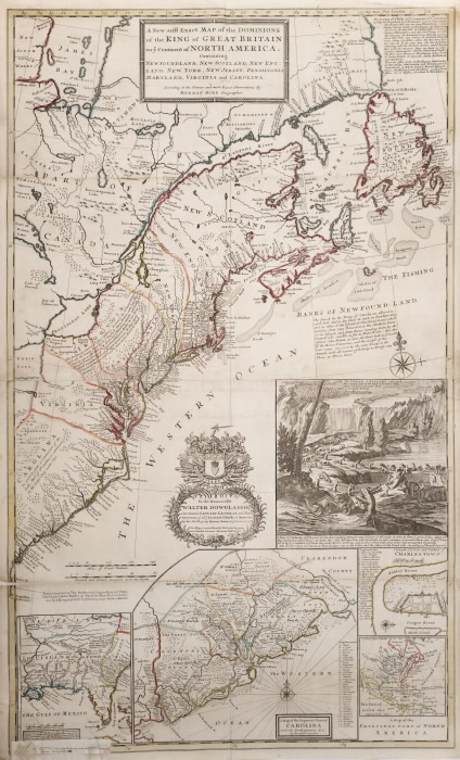
Old maps are vitally important for genealogy because the characteristics of a location can change in many ways over time. Historic maps help us understand the world as it was at the time our ancestors lived. 

Here is a short list of just a few of the things that may have changed:

  • Street addresses
  • roads 
  • town names
  • county boundaries
  • waterways that may have been filled in or opened up
  • railway lines 

In fact, the country itself where they lived may be a completely different country. For example, my German ancestors lived in Prussia in the 19th century. Today, that area is part of Poland. Therefore, all of the village names have been changed to Polish names. 

The David Rumsey Map Collection is an excellent place to go to find maps of your ancestors homeland for free.

Best way to find old maps at David Rumsey

Watch the Map Search Video

I’m going to explain the 7 steps to finding the maps you need for your genealogy research at this wonderful website! I highly recommend that you watch the short video below to see it in action as you read. The player will stay with you as you scroll down the page. 

Step 1: Go to the David Rumsey Map Collection Website

The first thing you need to do is go to the David Rumsey website here. You’ll be greeted on the home page with glorious historic maps. (Stay focused because it’s easy to get distracted by all the fascinating maps!)

Old maps for genealogy at David Rumsey website

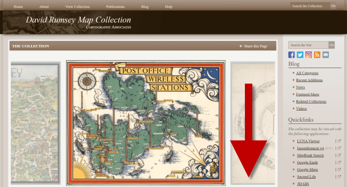
Scroll down on the David Rumsey website home page.

Step 2: Scroll Down to the Bottom of the David Rumsey Home Page

While you can search for a place name in the search box at the top of the page, there’s a better way to search. Scroll down the page until you get to Featured App: MapRank Search (it’s almost at the bottom.)

Step 3: Launch Map Rank Search

The Featured App – MapRank Search is the best place to search the website, but it’s easy to miss because it’s not at the top. So go ahead and click the Launch MapRank button in the upper corner of this section. 

launch map rank search at David Rumsey website

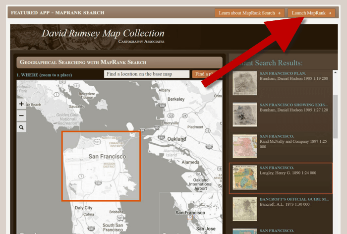
In the Featured App: MaprRank Search section click the Launch MapRank button

When you click the button it will open a new tab in your web browser which will take you to the Geographical Searching with MapRank Search page.

Quick Tip: The Fastest Way to MapRank Search

You can get there faster by going directly to https://rumsey.mapranksearch.com. I didn’t take you straight there from the beginning because I think it’s important to be aware of the home page and everything else it offers. However, today our focus is conducting the optimal search for old maps for you family history. 

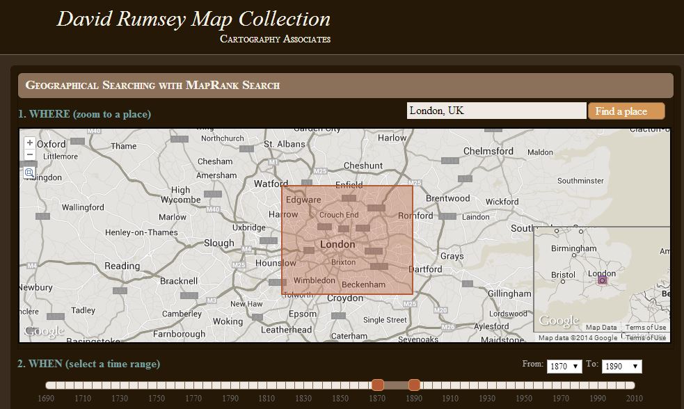
Step 4 Selecting the Map Time Frame

Here’s what the search page looks like. 

David Rumsey MapRank Search Page

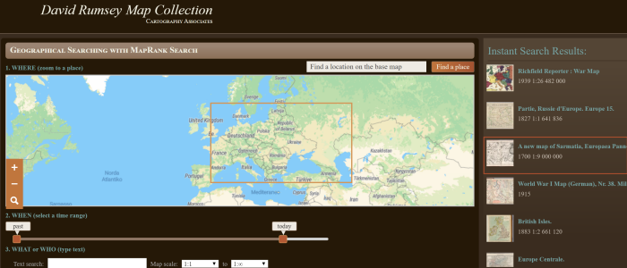
The DavidRumsey.com search page

There are two very important features on this app page that will help you get the best results possible: the time slider and the location search box.

The time slider is located beneath the map:

Timeslider for map search

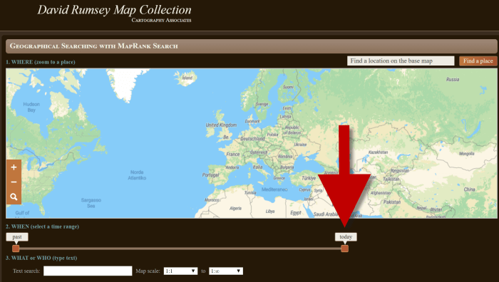
Time Slider for searching maps by time frame

It’s important to first select the time frame that you are searching because that will dictate the results you get when you search on the location name. (We’ll get to that in just a moment.) 

There is a slider on each end of the timeline. Slide them to specify the desired time frame. In my example below, I’m looking for maps between 1800 and 1900. 

time slider for map search

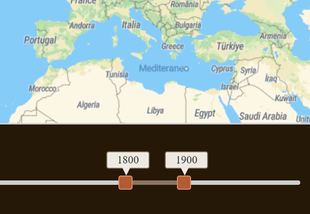
Searching for maps between 1800 and 1900

As you move the sliders, you’ll notice that the maps in the right hand column will change. This is because only maps that fall within the range you select will be offered in the Instant Search Results column. But before we look at those, we need to type in a location in the next step.

Step 5: Selecting the Location

With your time frame selected, now you’re ready to type the location in the search box.

As you type, the app will make suggestions. But wait! Before you click the Find a Place button to run the search, look carefully at the list of suggested locations that may appear. Many locations names can be found in different areas. That is certainly the case with the name of the tiny village where my great grandfather was born: Kotten.

searching a location for maps

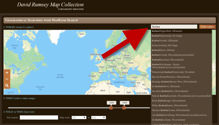
Type the location name to search the maps

In fact, the list doesn’t even include the Kotten I am looking for.

In cases like this, it is best to search a little more broadly. When Kotten was part of Prussia, it was located in Kreis Johannisburg so I could try searching for that. Even better might be to search for the largest city in the area since Kotten was such a tiny village. Arys was the largest city in the area. 

Once you type in the name (and select from the suggestions if needed) click the Find a Place button just to the right of the search box. 

Step 6: Analyze the Map Results

In my example of searching for the city of Arys (which is the name it was known by in the 19th century when it was part of East Prussia) the modern-day map displayed is actually Poland.

Poland map

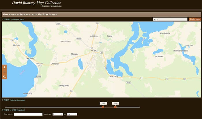
My search resulted in a map showing Orzysz, Poland

However, the David Rumsey website does a good job of cross-referencing the older German names (Arys) with the new Polish names (Orzysz). This is another reason why searching for a larger city works well. Larger cities are more likely to be in the David Rumsey system for cross-referencing, and of course they are easier to spot on the map. Generally speaking, the location you searched will be in the center of the display map. 

Quick Tip: Verifying Location Names

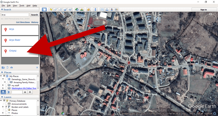
Another quick way to cross-reference location names (or verify your findings in David Rumsey) is by searching for the name in Google Earth. In the example below, I typed in the Prussian city of Arys. Google Earth will offer options if more than one matching result exists.

I was a bit surprised to see “Arys” as one of the three listed results since it is not called that today. When I clicked Arys it took me to the city of Arys in the Turkistan Region of Kazakhstan, far away from Poland! Clicking Orzysz in the results list took me to the area of Poland that was once East Prussia. This confirms the results I received at the David Rumsey website. 

Finding a map location in Google Earth

Learn more about using Google Earth for Genealogy by watching my free class here

Now it’s time to review the map results listed in the Instant Search Results column on the right. Isn’t it fantastic that David Rumsey’s website not only presented me with the correct Polish location, but also maps published between 1800 and 1900 that include Arys? I think so! 

Finding the city on the David Rumsey map

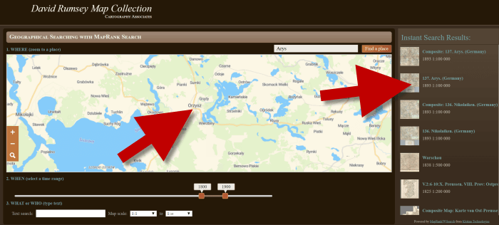
Map results appear in the column on the right side of the page.

Click the map you think best suits your needs. The map will open in in a new tab in your web browser. (These browsers tabs provide a nice bread crumb trail for your searching activities.) 

All of the source information about the historic map that you chose will appear in the column on the left. (See the image in Step 7.) If you decide to use this map you’ll definitely want to accurately cite the source. Learn more about the importance of source citations here.

Step 7: Export the Map

I was delighted to find the village of Kotten on this map of Arys published by Reichsamt fur Landesaufnahme in 1893!

When you find a map that you would like to use for your family history research, export it to your computer. To do this, click Export in the upper right corner of the map and select the desired size. You can select a size ranging from Small Thumbnail to Extra Extra Large. Keep in mind that the larger the size, the more clarity you will have as you zoom in closer and closer. This is very important if you plan on using the map in an overlay in Google Earth. You can learn how to create your own map overlays in my video tutorial series on using Google Earth for genealogy available here, and in my book The Genealogist’s Google Toolbox.

how to export an old map

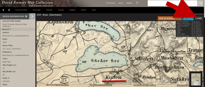
Click “Export” to save the map to your computer.

Be patient while downloading to your computer because it can take several moments to export a large map. The saved file will probably be zipped. To unzip it, on a PC right-click and select Extract All from the pop-up menu. This creates an open version of the folder containing the map. 

Get Started Finding Your Ancestral Locations in Old Maps

With this step-by-step process you are now ready to explore any given ancestor’s world through the rich details of historic maps. I can’t wait to hear what you discover! Please be sure to leave a comment below. And if you found this tutorial helpful, will you please share it with your friends on social media so we can help even more people find the homes of their ancestors? Thank you!

Travel Back in Time with Genealogy Records Newly Online

This week’s roundup features rare, unique, and just plain fun new collections available online or coming soon. Go back in time to 1923 with new public domain additions, explore San Francisco as it was in 1940 online and in Google Earth, keep an eye out for rare Caribbean newspapers, a free database of Washington State newspapers, and a new collection from the Digital Library of Georgia. Get ready to time-travel and find your ancestors!

A Peek Into 1923

For the first time in 20 years, new works are entering the public domain in the United States and those works were all published in 1923.  From the Internet Archive’s recent announcement, “Settle in with a Reese’s Peanut Butter Cup, a Butterfinger, or a refreshing Popsicle (all invented in 1923!)” and explore the films, popular music, and entertainment from 1923. This update also includes 20,000 texts like newspapers, books, and poetry. You can browse fashion magazines, sheet music, and so much more. Get a glimpse into life in 1923, and your ancestor might just be hiding in plain sight!

San Francisco: David Rumsey Maps

Recently recovered after decades of dusty storage, and immense 42- by 38-foot wooden replica of the city of San Francisco as it was in 1940 has been cleaned and photographed by a dedicated team of individuals as part of the SFMOMA and San Francisco Public Library project called Public Knowledge: Take Part. The model is comprised of 158 pieces at a scale of 1 inch to 100 feet.

From David Rumsey’s website announcement: “The model pieces were expertly photographed by Beth LaBerge. David Rumsey created the large Composite image [right] of the 158 pieces, as well as the image and metadata database of all the images, which he hosts. Rumsey also georeferenced the large Composite image and placed it in Google Earth.”

[Image right courtesy of www.DavidRumsey.com]

Caribbean Newspapers

The University of Florida has received a grant to digitize Caribbean newspapers. From the announcement (scroll to second article on the link page): “The grant award will support a continuing partnership between the George A. Smathers Libraries at the University of Florida and the University of Puerto Rico (UPR)-Rio Piedras Campus Libraries to digitize each institution’s unique, hidden holdings of Caribbean newspapers on master microfilm. The team, partners of the Digital Library of the Caribbean, will digitize and make freely available 800,000 pages of pre-1923 Caribbean newspapers.”

Washington State Newspapers

From the Washington Secretary of State: Browse and search historical publications with new Washington Digital Newspapers website. “The site features new titles in the State Library’s digital newspaper collection, with full-text article search of more than 400,000 pages from the State Library’s collection of historic Washington newspapers. Visitors can interact with the site with the help of text correction features to improve search results on dark or damaged pages, by attaching subject tags to articles, and saving their search history for larger research projects.”

Visit https://washingtondigitalnewspapers.org/ to start browsing now!

Digital Library of Georgia

The Digital Library of Georgia has recently announced a new collection for Atlanta’s Interdenominational Theological Center and Morehouse, Morris Brown, and Spelman Colleges. “As part of the CLIR-funded, ‘Our Story’ project, Atlanta University Center, Spelman College, and the DLG are happy to announce additional content documenting the largest consortium of African American private institutions of higher education.” In this collection, you’ll find scholarly journals, yearbooks, photographs, course catalogs, and more. 

Additional “Our Story” updates are available through the DLG blog.

More genealogy time-travel

Time travel technology may not be available yet, but Lisa’s Premium eLearning Video is the next best thing! You’ll discover ways to find content that can immerse you in the past to explore the cultural and historical events, places, and people that affected your ancestors’ lives. You’ll explore interactive timelines, advances in video, and geographic tools that can dramatically impact your understanding of your family history. Plus a downloadable handout is included. Available now to all Premium eLearning Members! (Not a member? Sign up today!)

Lacey Cooke

Lacey Cooke

Lacey has been working with Genealogy Gems since the company’s inception in 2007. Now, as the full-time manager of Genealogy Gems, she creates the free weekly newsletter, writes blogs, coordinates live events, and collaborates on new product development. No stranger to working with dead people, Lacey holds a degree in Forensic Anthropology, and is passionate about criminal justice and investigative techniques. She is the proud dog mom of Renly the corgi. 

Disclosure: This article contains affiliate links and Genealogy Gems will be compensated if you make a purchase after clicking on these links (at no additional cost to you). Thank you for supporting Genealogy Gems!

New Pictorial Maps on David Rumsey Map Collection

Map of Hollywood, 1928. Online at David Rumsey Historical Map Collection. Click on the map for full citation information.

Map of Hollywood, 1928. Online at David Rumsey Historical Map Collection. Click on the map for full citation information.

Pictorial maps are both fun and useful for finding our family history. These use illustrations in addition to regular cartographic images to communicate their messages.

For example, this 1928 map of Hollywood, California, inserts faces of the famous and illustrations of local attractions. But maps like those don’t just exist for popular tourist destinations. And now there are even more pictorial maps online and FREE to use at the David Rumsey Map Collection.

According to a press release, “Over 2,000 pictorial maps and related images have been added…in the form of separate maps, pocket maps, case maps, atlases, manuscript maps, and wall maps.”  These include “certain panoramic and birds-eye maps, diagrammatic maps, and timelines.” Pictorial maps were especially popular during the 1920s-1940s, but David Rumsey includes many from the 19th century and before. The collection continues to grow; check back often to look for the maps you want most.

Genealogy Gems Premium Membership and PodcastDid you know that I teach an entire video class on using historical maps in genealogy research? I’ve put a free excerpt on the Genealogy Gems YouTube Channel: Using Sanborn Fire Maps for Genealogy and Family History. Watch it below! Genealogy Gems Premium members can watch the full class, which goes in-depth on four MORE types of helpful historical maps, and download the companion handout! (Click here to learn more about Premium membership.)

Love Finding Old Maps Online? Help “Index” Them!

The Beaver Map, 1715. By Special Collections Toronto Public Library. Flickr, via Wikimedia Commons.

Recently I’ve seen two calls for volunteers to help “georeference” old maps. Basically, you’re tagging the maps in a way similar to tagging photos of people on social media sites. This makes finding old maps online easier and more accurate. It also allows sites to overlay the old and new maps. “Some places have changed significantly or disappeared completely, creating a puzzle that reveals an exciting contrast,” explains the British Library.

These two sites are asking for volunteers:

The British Library Online Gallery. The British Library is asking for volunteers to help georeference 50,000 maps it’s put online. Go right to the site and you’ll see the invitation to help on the home page. You’ll also see that you can click on a tab to search maps that are already georeferenced! The British Library tells its volunteers: “Your name will be credited, and your efforts will significantly improve public access to these collections. Contributors can see the results of their work, as well as the progress of the pilot and other participants, and the top contributor will be publicly announced.”

David Rumsey Historical Maps. This mega-maps site is also looking for volunteers to help add locations to its online map collections. On the home page, click on the left where it says Georeferencer: Help Add Location to Maps.

We blog about maps a lot here at Genealogy Gems. To learn more about using old maps online and for genealogy, go to our home page and search on the Maps category on the lower left side of the page. Additionally, Genealogy Gems Premium members have access to full-length video classes like these:

Not a Genealogy Gems Premium member? Click here to become one!

Using Google Earth for Genealogy: Q&A

all_over_the_map_anim_300_wht_13636Have you ever found yourself looking for an ancestor’s address that doesn’t seem to exist anymore? Here are some strategies I recently shared via the following Q&A:

Question: From the 1881 Census in England I uncovered the address for my relative: 3 Buckingham Mews, Kensington Place, London, England.  When I enter this in the search it gives me 3 Buckingham Mews, Westminster, London,UK.

I don’t know anything about London so I don’t know if this is the same thing but just with current location names.  Any suggestions?

My Answer: As with many genealogical questions, this is a question that will likely require several sources in order to answer. I’ve been to London many times and my perception is that Kensington and Westminster are separate areas. Boundaries have certainly changed over the years in London, and England at large though. Here is the direction I would suggest:

1) Google Earth – a search of 3 Buckingham Mews, Kensington actually delivers 3 possible locations (2 in “London” and 1 in “Westminster”). You can save each one to My Places (I would recommend creating a folder especially for this question). At the bottom of the results list you will see an icon that looks like a folder with a down arrow. Click it to download the locations to MyPlaces. Also, be sure to run a search simply on “3 Buckingham Mews” and let Google Earth show you all the possibilities.

2) Go back to your original source: the census. Since there is confusion about the address of your ancestor, look for other addresses listed nearby and plot those in Google Earth. My hunch is that you will begin to build a profile of the census area, and see the relationship between that neighborhood and the 3 results Google Earth delivered.

3) Check Rumsey Historical Maps in Google Earth – LAYERS > GALLERY > RUMSEY (click the Rumsey box). You may need to zoom out a bit to locate the available historical maps. You’ll find that there is one from 1842.

4) Search for applicable maps at the David Rumsey Historical Map Collection. On the home page scroll down and click “Launch Map Rank Search.” From that page you can select London, and then narrow in on the time frame. I would go for a spread of 1870-1890 (see below: you’ll move both pink boxes to set the time parameters on the timeline). There are several excellent maps available to download from that query. Sign up for a free account on the website and you will be able to download the highest resolution maps. You can also, of course, work with the map right on the website.

David Rumsey London 1870 1890 screenshot

5) Google Search – Run some searches on the history of London boundaries and boroughs. Here’s a link to a page a found in Wikipedia  on “London boroughs.”

By exploring multiple sources you should be able to create a “data visualization” that zeros in on the correct location. I hope you’ll share what you find with me!

Google Earth for Genealogy Bundle

Want to learn more about using Google Earth for genealogy? I offer a 2-CD bundle that demonstrates how to:

  • download and use Google Earth;
  • identify where old pictures were taken;
  • explore church record origins;
  • plot ancestors’ homesteads and pinpoint their properties;
  • create custom historic map overlays;
  • save and share images and videos;
  • customize placemarks;
  • create 3D models of ancestral locations; and
  • create unique family history tours. Click here to learn more!

Pin It on Pinterest

MENU