Looking for enumeration district maps for the U.S. Federal Census? You’re not alone! Recently Genealogy Gems podcast listener Michelle in Denver,
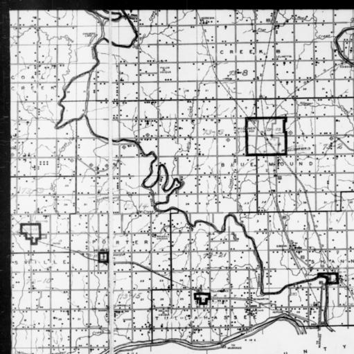
1940 Census Enumeration District Map, Oklahoma, Wagoner County, http://research.archives.gov/description/5836456
Colorado, wrote in with this question:
“Where can I find individual enumeration district maps? I don’t need a state-wide map showing the divisions between enumeration districts, but a map showing the numbered households within a single enumeration district.”
My answer: How to find Enumeration District Maps
First, here’s a little back story from the National Archives (U.S.) website:
“An enumeration district, as used by the Bureau of the Census, was an area that could be covered by a single enumerator (census taker) in one census period. Enumeration districts varied in size from several city blocks in densely populated urban areas to an entire county in sparsely populated rural areas.
Enumeration district maps show the boundaries and the numbers of the census enumeration districts, which were established to help administer and control data collection. Wards, precincts, incorporated areas, urban unincorporated areas, townships, census supervisors` districts, and congressional districts may also appear on some maps. The content of enumeration district maps vary greatly.
The base maps were obtained locally and include postal route maps, General Land Office maps, soil survey maps, and maps produced by city, county, and state government offices as well as commercial printers. Census officials then drew the enumeration district boundaries and numbers on these base maps.” (Check out the full article here.)
Enumeration district maps are not available in all years and all locations. 1940 is the most accessible. These are available on the National Archives (U.S.) website. (Scroll down to item 3 for instructions on getting to these through the Online Public Access search.) You’ll see that only the enumeration district numbers and street names are marked on the maps. Individual homes are not.
What about enumeration district maps before 1940? Consult Cartographic Records of the Census Bureau for maps in the National Archives.
For censuses before 1900, the government used voting districts as enumeration districts. Find voting district maps in the Library of Congress book, Ward Maps of the United States : A Selective Checklist of Pre-1900 Maps in the Library of Congress. (The links here lead to WorldCat search results for these titles. WorldCat will tell you about libraries that have these books.)
If you just want to find the enumeration district number of an address you already know, go to the Unified Census ED Finder at Steve Morse’s One-Step genealogy website.
Here are a couple more thoughts:
- In cities, there are often two columns of numbers in the census population enumeration (typically on the far left of the page). There’s house number and the number representing the order in which the enumerator visited the house (which has nothing to do with the house number). If you can’t find a relative in once census, pull the address from one census and use it in the Steve Morse database above to pull up the enumeration district for your missing decade.
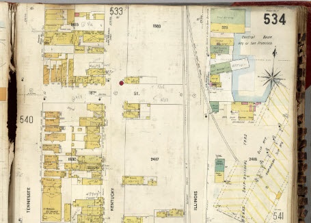
- Depending on the year you are researching, try to locate a Sanborn fire insurance map for the area. Sanborn maps do include drawings of individual homes and include their house number. Genealogy Gems Premium Podcast Episode 47 is all about Sanborn fire maps. On the show notes page I even include a list of links to many Sanborn map collections, organized by state.


