There is a fantastic blog posting on Mad About Genealogy about the Booth Poverty Maps, which look like a riveting way to understand your ancestor’s 1880s London neighborhood.
According to blogger Linda Elliott, “Booth employed a team of social investigators who walked around the London streets often in the company of the local policeman and recorded what they saw and heard. The notebooks that they filled out can be viewed online and make for fascinating reading with amongst other findings they record what the policeman thought of each street and sometime each building and its inhabitants.”
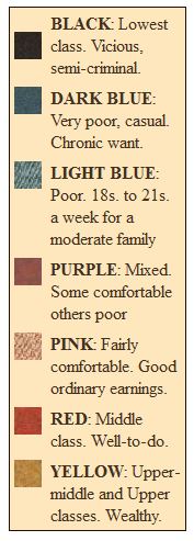
I’ve shown the map key here (right), clipped from The Charles Booth Online Archive. Linda describes each category in greater detail in her blog post, along with everything a genealogist needs to know to use the maps.


