Blog


How to Find Cemeteries in Google Earth
Do you ever wish there was a master map of all the cemeteries in the world? While there isn’t one map that includes every single public and private cemetery around the world, the free software program Google earth offers up something close. Here’s what you need to know about how to find cemeteries in Google Earth.
Lisa Louise Cooke: teaching Google Earth for Genealogy since 2007.
These days Google Earth is a free software program, a web-based program and a mobile app. Each form of the application has it’s own merits, and today we’re going to explore one of the software’s best features: the ability to map out cemeteries around the world, and gather valuable information about them. This feature is particularly useful for the family historian who wants to learn more about their ancestors, including where they are buried.
But before we get started, you need to check to see if you have the latest version of Google Earth downloaded to your desktop or laptop computer. On your desktop, look for a grey and white globe. If you see a blue and white globe, you have the older original free version of Google Earth. However, a few years ago, Google made their Google Earth Pro version free to everyone, and it is now the standard.
If you do have Google Earth Pro (the grey globe software) then you’re ready to go.

The grey Google Earth globe on the desktop.
If you don’t have it, then you will need to download it.
How to Download the Free Google Earth Software:
- Go to http://www.google.com/earth/download/gep/agree.html
- Click the blue download button
- Read the Terms and Conditions
- If you agree to them, click the Agree and Download button
- Follow the installation guide
- When complete click Run Google Earth
Now that you have Google Earth on your computer, launch it and look on the lower left side of the screen. There you will find the Layers panel.
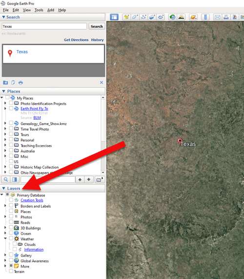
The Layers Panel in Google Earth.
Google Earth Layers are collections of points of geographic interest that have been curated by Google Earth or its content partners. When you click on a Layer, it brings up all those points of interest on your current view of Google Earth.
You’ll find the Layers panel on the bottom left side of your screen. To display all points of interest within a Layer, click the box next to the Layer title. To open a Layer category, click the plus sign next to the label to open the Layer folder, and the minus sign to close it.
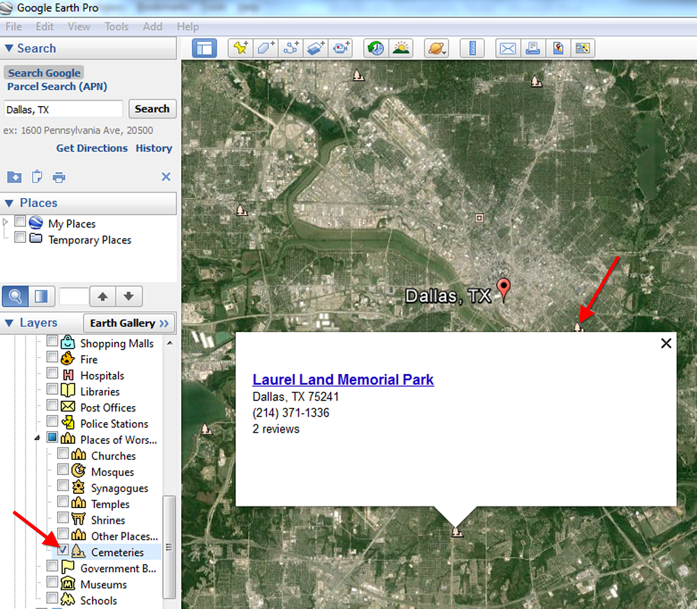
There are lots of genealogically-interesting Layers, including Cemeteries. You will find Cemeteries in the More > Place Categories > Places of Worship layer. Make sure the box next to Cemeteries is checked. You’ll see the little buy hiv medication online icon showing a tree with a little headstone next to it.
Next, search for a location in the Search box to “fly” to a neighborhood in Google Earth where you’d like to find nearby cemeteries. Look for those Cemetery icons. You may need to zoom in or out for them to appear. While not every cemetery is shown, it’s an excellent start!
Click on a cemetery icon. This will open a dialog box containing relevant information about the cemetery, often including the address and telephone number. If the cemetery title is hyperlinked, click it for even more useful information.
I hope you enjoyed learning how to find cemeteries in Google Earth. You can learn more about using Google Earth for genealogy in my book, The Genealogist’s Google Toolbox, Second Edition, fully-revised and brand new for 2015. It’s got five chapters devoted to how to use Google Earth for genealogy that are filled with more tips like this one.
And one more thing: did you know that Google Earth Pro is now available for free? Click here to read my post with all the details.
Happy Googling!

Meet the Library of Congress in 3 Short Video Clips
The Library of Congress (LOC) is a dream destination for many U.S. genealogy researchers. It’s home to millions of books, maps, city directories,

“LOC Main Reading Room Highsmith” by Carol M. Highsmith – This image is available from the United States Library of Congress’s Prints and Photographs division under the digital ID highsm.11604.
photographs and other materials that can help us better understand our ancestors’ lives.
A guided walking tour of the LOC will take an hour (and a trip to Washington, D.C.), but the videos below introduce you to the library and its online resources in seven minutes.
Bonus: there’s a third two-minute video below with the fastest introduction to analyzing primary sources you’ve ever seen. Click below to watch!
VIDEO: The Library of Congress Is Your Library. This four-minute video introduces the Library of Congress and gives a brief history.
VIDEO: Exploring LOC.gov. This three-minute video highlights the Library’s online collections and provides searching techniques. If you haven’t searched the Library of Congress website for items relating to your U.S. family history, take a few minutes and try it now!
VIDEO: Analyzing a Primary Source. This two-minute video offers a a short primary source analysis activity. It’s meant for teachers but it’s a great reminder for family historians on how we look at old documents.
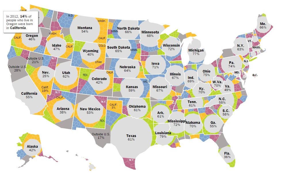
Did your family follow the usual path? Mapping U.S. Migration Patterns

Mapping Migration in the United States. From the New York Times. Click to go straight to the source!
The U.S. has long been typified as a nation of restless wanderers. Are we still? Well, it depends on where in the U.S. you are from.
A new interactive infographic on the New York Times website looks at U.S. migration patterns: where residents of each U.S. state in 1900, 1950 and 2012 were born. According to the accompanying article, “You can trace the rise of migrant and immigrant populations all along the Southwest, particularly in Texas and Arizona, the influx of New Yorkers and other Northeasterners into Florida starting in the 1970s; and the growth in the Southern share of the Illinois population during the Great Migration.”
“In 1900, 95 percent of the people living in the Carolinas were born there, with similarly high numbers all through the Southeast. More than a hundred years later, those percentages are nearly cut in half. Taken individually, each state tells its own story, and each makes for fascinating reading.”
If you live in the U.S. now, click on your state to zoom in. You’ll see the statistics more fully represented. How many natives of that state still live there? Where else are its residents from? Where do you fall in? I am one of less than 1% of Ohioans who was born in a western state (excluding California). My husband and children are among the 75% of Ohio natives who still live here.
It might surprise you how little–or how much –your fellow state residents have been on the move. Now turn back the clock by clicking on the 1900 or 1950 maps. How did your family fit the norms for the time?
 If you love learning history through maps, go to our Home page and click on the Maps category in the lower left under Select Content by Topic. You’ll find lots more great online map resources and plenty of great map research strategies.

