by Lisa Cooke | Feb 27, 2015 | 01 What's New, images, Maps, United States
 Do you have ancestors who lived in the “Windy City” of Chicago, Illinois (USA)? You should check out Chicago in Maps, a web portal to historic, current and thematic maps.
As the News-Gazette reports, “There are direct links to over three dozen historic maps of Chicago, from 1834 to 1921. The thematic maps include Chicago railroad maps, transit maps and geological maps.”
Of course, there are current maps, too, including a Chicago street guide for 2014. There’s a fascinating set of maps showing the effects of landfill projects. The Sources and Links page directs users to helpful guides to street name changes and house numbers. You’ll find links to surveyors’ maps, too.
From the home page, you can also click to a sister site on Chicago streetcars that includes a 1937 map of streetcar lines. (There’s a second sister site on Chicago bridges.)
 Genealogy Gems Premium members can learn more about using maps for family history research in my online video class, 5 Ways to Enhance Your Genealogy Research with Old Maps. To learn more about the benefits of Premium membership (including a year’s full access to over 2 dozen full-length video classes), click here.
by Lisa Cooke | Jan 13, 2014 | 01 What's New, Google, Maps
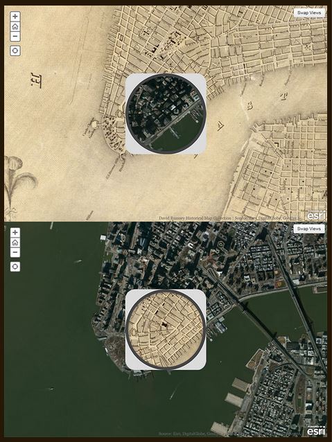
1836 map of New York City compared to modern satellite image, shown with each map in “spyglass” format. Image from David Rumsey Map Collection blog at DavidRumsey.com.
I love showing people how to use online tools to compare historical maps to modern ones. You can map out your ancestor’s address, check out their neighborhoods “then and now,” map their route to work, see if their old home still exists and more.
Well, the online Smithsonian magazine has created an exciting new interface for six American cities. Now you can compare modern satellite imagery with bird’s-eye views of:
You’ll see great city layouts before the fire that claimed much of old Chicago, the San Francisco earthquake, the Lincoln memorial and more. The historical map of New York City is the oldest, but the other maps capture each city at a critical point in their growth. For each city you can look at a historical map with a “spyglass” mouse-over of a modern satellite image, or vice-versa, as shown in the New York City map on the right. Each map is accompanied by a fantastic Smithsonian article; the historical maps come from the amazing David Rumsey Map Collection.
As many of you know, it’s possible to do something similar (or even better) with Google’s amazing mapping tools. Learn how to do that with these three Genealogy Gems resources:
1. My FREE Google Earth Video, which teaches you how to unlock mysteries in your research, from unidentified photographs to pinpointing homesteads;
2. My Google Earth 2-Disk Bundle, with detailed demonstrations and examples so you can SEE for yourself how to use Google’s mapping tools;
3. My new Time Travel with Google Earth video, in which you’ll see old maps, genealogical records, images, and videos come together to create stunning time travel experiences in Google Earth. This is available to Genealogy Gems Premium Members (learn more membership here).

 Genealogy Gems Premium members can learn more about using maps for family history research in my online video class, 5 Ways to Enhance Your Genealogy Research with Old Maps. To learn more about the benefits of Premium membership (including a year’s full access to over 2 dozen full-length video classes), click here.


