When you need help deciphering place names in hard-to-read genealogy documents, two free online tools may have great suggestions for you. Use them to take the guesswork out of identifying great-grandpa’s hometown!
Thanks to guest blogger Katherine Schober, expert German translator and author of the new book,Tips and Tricks of Deciphering German Handwriting, for this article on deciphering place names (or anything else) in hard-to-read old documents.
There are times when you know from the context of an old document that a certain handwritten word is a city or town–but you aren’t sure of the exact letters the scribe has written. Perhaps you can make out most of the name, but not the first letter. Or maybe you can’t tell whether you’re looking at an “r” or an “n” in the middle of the word. Other times, you can read the place name, but this particular spelling doesn’t appear on a map.
Deciphering place names with a simple trick—and 2 free online tools
Two online resources that are very helpful for identifying town names are Google’s search engine and Meyer’s Gazetteer. At both sites, you can enter what you do know and have these sites help suggest possible place names.
Google search suggestions
Type your transcribed town name intoGoogle—along with any other known place clues, such as the county/province or country name–and see if you get any search results for the region you are researching. If you do, congratulations, you likely transcribed it correctly!
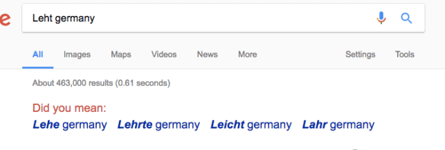
If not, Google may actually suggest the correct transcription of your word for you. For example, when I was translating a nineteenth-century document a few months ago, I read the letters of the town as “L-e-h-t”. I typed “Leht, Germany” into Google, and waited to see what search results would appear. As it turned out, there were no search results for “Leht, Germany,” but Google’s “Did you mean…” function actually provided four other possibilities for what I could have meant as a town name! Here’s what it gave me:
After comparing these Google suggestions with my handwritten word and the specific region of Germany, I realized that the word actually had an “r” and an “e” squeezed in and was, therefore, the German town of “Lehrte.” Taking advantage of this “Did you mean” feature of Google can be very helpful when trying to decipher city and town names.
(Learn hundreds more tips on using Google search–and all the other free Google tools–in Lisa Louise Cooke’s popular book,The Genealogist’s Google Toolbox.)
More help from Meyer’s Gazetteer
If you can only recognize the first few or the final few letters of a German town,Meyer’s Gazetteeris the site for you. Meyer’s Gazetteer is a free database containing names and information on pre-World War I German cities, towns, and villages (meaning that this site includes towns in present-day France, Poland, and other places). Type in the letters you recognize in your word and use an asterisk to represent the letters you don’t. Meyer’s Gazetteer will then provide you with a list of all places with your letter combination. Then you can then see if there is a town that matches your handwritten word and region.
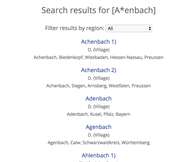
In the example below, I recognized a capital “A” at the beginning of the word. The middle letters looked like a scribble, but I could see “e-n-b-a-c-h” as the final letters of the word. I typed this into Meyer’s Gazetteer, using an asterisk for those unclear middle letters. The website then provided me with a list of possibilities, and–by only looking at the town names in my specific German region–I was able to significantly narrow down what my handwritten town name could be. By comparing this list to my handwritten word, I was able to then decipher the remaining letters and figure out the name of the town. (Click herefor more tips on using Meyer’s Gazetteer.)
By taking advantage of the resources available online, you can make your transcription process much easier and much more fun. Best of luck!
Disclosure: This article contains affiliate links and Genealogy Gems will be compensated if you make a purchase after clicking on these links (at no additional cost to you). Thank you for supporting Genealogy Gems!
Old maps are an essential tool for discovering more about your family’s history. If you have exhausted more traditional sources, here are three places to find maps that may surprise you.
#1 Surprising Finds within the David Rumsey Map Collection
You’re probably aware that the David Rumsey map collection website is a terrific source for old maps. But you may be surprised by the variety of maps, some which you likely don’t come across every day. Here’s a fun little tactic I took today to see what it may hold in store beyond typical maps. A search of the word neighborhood reveals that their holdings go well beyond traditional maps. Here’s an example from San Francisco showing a neighborhood in its infancy:
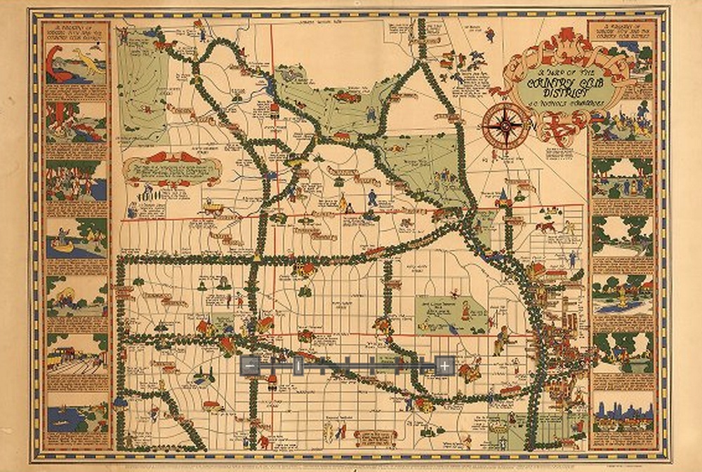
And the image below depicts the Country Club district of Kansas City in the 1930s. If your family lived there at that time, this is a real gem.
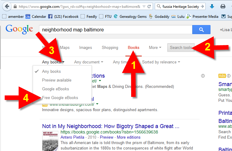
If you think Google Books is just books, think again. Historic maps, often unique and very specific, can often be found within those digitized pages. Try running a Google search such as: neighborhood map baltimore.
Click the MORE menu and select BOOKS. Then click the SEARCH TOOLS button at the top of the results list, and from the drop down menu select ANY BOOKS and then click FREE GOOGLE BOOKS:
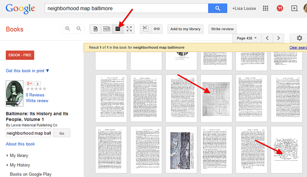
Select a book that looks promising. Then rather than reading through the pages or scanning the index, save loads of time by clicking the thumbnail view button at the top of the book. This way you can do a quick visual scan for pages featuring maps!
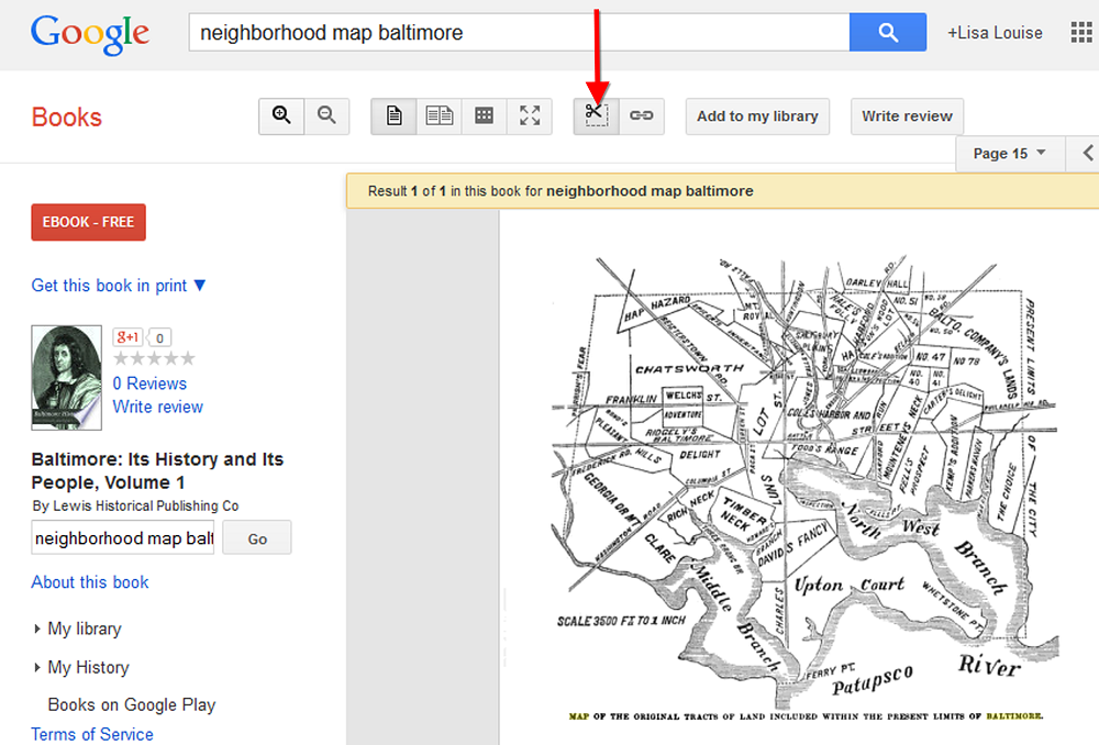
When you find a page featuring a map, click it display it on a single page. You can now use the clipper tool built right in to Google Books to clip an image of the map. Other options include using Evernote (free) or Snagit ($).
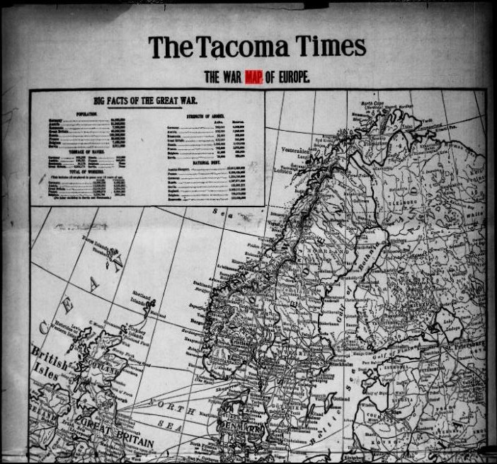
Like Google Books, the digitized pages housed at the Chronicling America website contain much more than just text. Old newspapers printed maps to help readers understand current events like the progress of war or the effect of a natural disaster. This map from The Tacoma Times in 1914 shows a map of Europe and several quick facts about the “Great War,” World War I:
The Tacoma Times, August 22, 1914. Image from Chronicling America. Click on image to visit webpage.
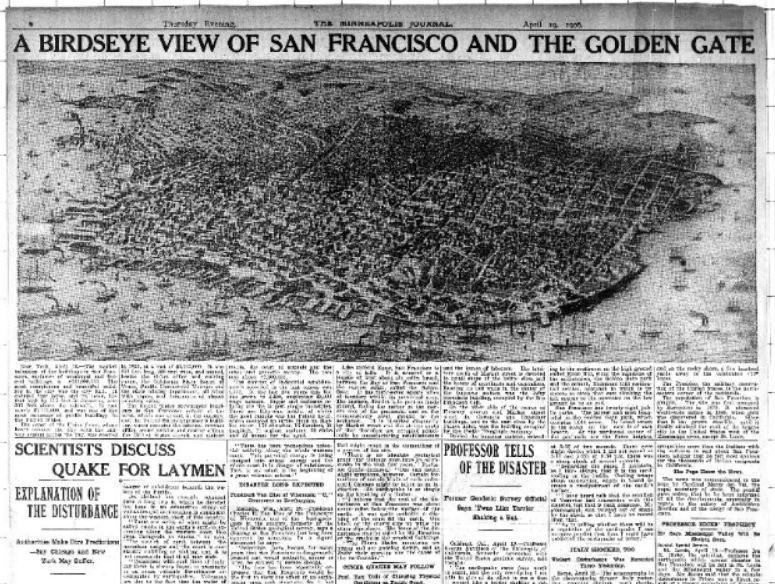
Here’s one more example below. A search for “San Francisco earthquake” at Chronicling America brought up this bird’s eye view of San Francisco at the time of the major 1906 earthquake. Articles below the map explain what you’re seeing:
The Minneapolis Journal, April 19, 1906. Image at Chronicling America; click on image to see it there.
Do you ever get lost when looking for ancestral hometowns in Europe or other parts of the world? Boundaries change–national ones as well as regional ones. Place names change. Several little villages may all have gone by the same name over time. And darn those spelling and place name variants!
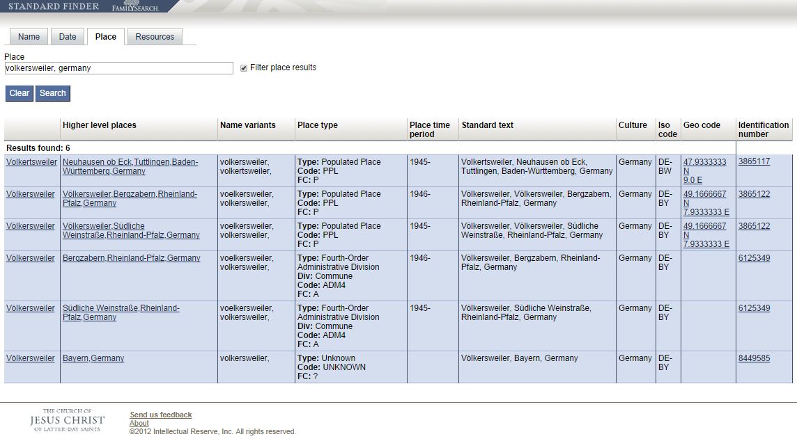
There’s a great online tool for finding places on a map. It’s the FamilySearch StandardFinder. Under the Place tab, enter the place name that’s got you befuddled. You’ll get a result screen that looks something like this:
What do each of those columns mean? We asked a Product Manager at FamilySearch and here’s what he told us:
Column 1: The official name of the place.
Column 2: Link/official name to the jurisdiction that the place exists within.
Column 3: “Normalized” variant names (i.e. other names the place is known by)
Column 4: General/high-level type (the type) of the place. Div: The more specific type (if applicable). Code: The code for the general type. FC: The feature code (taken from NGA’s feature code).
Column 5: The years within which the place existed (typically within the jurisdiction it belongs to).
Column 6: The full official (standardized) name of the place and its jurisdiction.
Column 7: Culture: The generalized culture that the place exists within.
Column 8: ISO code: The ISO code (if applicable).
Column 9: Geo code: the “centroid” (or central spot) of the place specified as the latitude and longitude.
Column 10: The permanent identifier of the place, useful for referencing the place within applications, systems, and products.”
A couple of these columns are a little technical for me, but I can still extract a LOT of information from these results! Place names, variant names, jurisdictions, lifespan of that location, latitude/longitude and all the possible places a possible location might be.
You’ll likely notice that there are Standard Finders for names and dates, too!
Google Maps Street View was given an edge today over Google Earth’s street view when Google launched a “time travel” upgrade. The ability to time travel is high on most family historians list, and Street View imagery for Google Maps desktop provides a taste of that prize.
According to Google’s blog post today they have “gathered historical imagery from past Street View collections dating back to 2007 to create this digital time capsule of the world.”
Here’s an example of viewing Gettysburg with the new feature. In many cases, there’s nothing earth shattering to see. But in some locations which have undergone substantial change in that short time period (such as viewing the reconstruction after the devastating 2011 earthquake and tsunami in Onagawa, Japan) the results are riveting.
Don’t worry if you don’t see Google Maps Street View Historical Imagery feature yet. When you have millions of users it can take a while to roll out upgrades.
Members Have Been Time Traveling for a While Now If you’re a Genealogy Gems Premium Member then chances are you made a bee-line for the Time Travel with Google Earth premium video as soon as you joined. In that video we explore some incredibly powerful ways to travel back through our ancestor’s lives and times. And while I still think that those techniques deliver more relevant results for genealogists, this new Street View time travel in Google Maps is exciting in its own way. It offers a glimpse into the future.
Consider this: Google has been amassing incredible amounts of data over its short life including satellite and street view imagery. 7 years in and they can now begin to offer this collection of older imagery in a meaningful way. Imagine what historical street view imagery will look like in 10, 25, or 50 years from now!
After Looking Back in Time, I Offer This Prediction for the Future
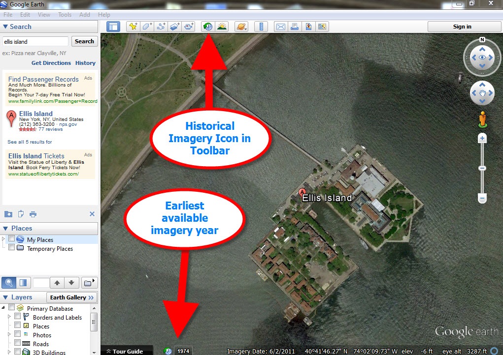
While this feature has just rolled out in Google Maps, and is not yet available in our beloved Google Earth, I predict this omission will not last long. You may have already noticed that as you zoom in closer to street level in Google Earth a small clock icon appears at the bottom of the screen indicating historical satellite imagery is available. Next to the icon a date now appears indicating the earliest available imagery. Click the Historical Imagery icon in Google Earth’s toolbar and a time slider indicating the years available will appear.
For most areas of the world this spans about as long as satellite imagery has been around. But in some key areas, such as London and parts of Europe, the slider goes back to the World War II era. Black and white aerial imagery of war torn areas are plainly visible. (If you have World War II veterans in your family tree, this is a feature you’ll want to explore.) It can only be a matter of time before this same Historical Imagery comes to Google Earth’s Street View.
More Ways to Explore and Time Travel Now
If you are intrigued by the idea of using this technology to simulate your own genealogical time travel experience, watch my free video called Google Earth for Genealogy. You’ll travel along with me as I uncover the secrets of a photograph taken just over one hundred years ago, pinpoint the location today, and then travel back in time to further explore my ancestor’s neighborhood. From there, the sky is the limit with Google Earth and Google Maps!