These days we are all collecting more ebooks than ever before. We also have more devices than we’ve ever had before. Here’s a solution that gives you access to your ebooks from one convenient location no matter which device you are using.
The Advantage of eBooks
While you may love the feel of the pages of a book rifling through your fingers, there is a distinct advantage to collecting many of your genealogical reference materials and books ebooks. They don’t take up precious shelf space in your house!
However, I don’t live in a digital fantasy-land. I’m keenly aware that there are some challenges you may want to avoid:
purchasing an ebook and downloading it to one device, and then trying to figure out how to access it on your other devices
corralling your ebooks from different sources all together
having to pay for an app or web service to manage them
Don’t Reinvent the Wheel
If you’ve ever attended one of my genealogy classes, or watched one of my videos, at some point you’ve probably heard me say that I use Google Books on a daily basis for genealogy. I don’t say that just because the service provides access to over 25 million books, many of them fully digitized and searchable, and downloadable. It also provides you with your own personal library. Let’s take a look at how Google Books and Google Play Books work together to make that possible:
Google Books is a free and powerful service that also allows you to have your own library within it called My Library. As you search for and find ebooks to aid you in your genealogical research, you can save them to your library.
Google Play Books, is sort of the other side of Google Books. It is a vast ebook store that includes a feature called My Books. When you purchase an ebook, it is saved to your My Books. However, it also includes all ebooks that you have saved to your Google Books My Library. Even better, it allows you to upload your own ebooks! This makes it a central clearinghouse for all of your ebooks.
Here’s the bottom line. Think of My Books and My Library as the same thing in two different places: a personal library for your free, purchased and uploaded ebooks. The only reason they have different names is because Google Books has evolved over time into a book store as well. Don’t worry about that. Just know that whether you are searching through Google Books, or shopping in the Play book store, your library is right there with you, no matter what device you are using.
How to Start Using your Google Play Books Library
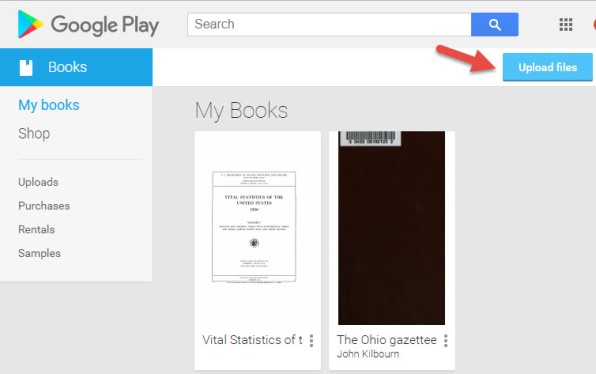
To get started, all you need is a free Google account, which you very likely already have. Go to https://play.google.com/books and sign in. In the menu on the left, click My Books. If you have ever saved a free ebook to your My Library in Google Books you should now see it on your screen.
This library is a place where you can save, upload, and access your digital books from any mobile device. This means everything is conveniently in one place, and accessible from all of your computing devices, both Apple and Android. You’ll have the freedom to read your favorite books on the go, and to access your digital genealogy research library at the drop of a hat.
Yes, there are some other services out there that could also do the job. But if you’re like me and don’t want to invest the time to learn and pay for yet another tech tool, Google Play Books is a great solution, because we are already using Google Books for our genealogy research.
How to Upload Your Own eBooks to Your Google Play Books Library
Let me walk you through the simple steps to putting this free tool to work for you:
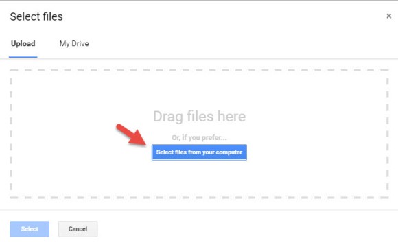
1. First, open your web browser and log in to your Google account.
4. Select your ebook files from your computer folders, or drag them into the box shown. You can also click on My Drive to select files from Google Drive. You can choose epub documents or PDFs.
Now, let me stop right here for a second and distinguish between doing this on a computer, and doing it on a tablet or smartphone. What I’m illustrating here is on a computer. I always recommend when you purchase ebooks to download them first to your computer, regardless of whether you plan on uploading them to Google Play Books. However, if you do want to do this on a tablet, for example, there are currently two options from which to pull your ebooks:
“My Drive” which is Google Drive, or
click “Select files from your computer” then tap “More” and select Dropbox.
Trust me, things will work more smoothly if you use your main computer as your hub for downloading, and then upload directly to your Google Books library.
Other things that are good to know:
It may take a minute or two to upload an entire book.
The cover will be the title page, not the actual dust-jacket cover you might be used to.
Currently, you can only search within books you obtain from Google (both free and paid), not the ones you upload.
You can upload 1,000 books into your Google Play Books library.
It’s private. Your books are only visible to you when you login to your Google account; you’re not sharing them with the world.
Your Google Books Library on Your Mobile Device
So now you have found free historical ebooks on Google Books (if you haven’t, take a moment and click here to read my article about using Google Books) and saved them to your Google Books My Library. Then, you uploaded your own ebooks and PDFs to Google Play Books. The final step is to jump on all of your smartphones and tablets and head to the app store. Search for Google Play Books and download the free Google Play Books app to each device. Sign in to the app with your same free Google account, and you’ll have access to all of your ebooks. Your library can now travel with you in your purse or tucked into your pocket.
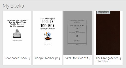
In the app, tap the three horizontal lines icon in the upper left corner, and then tap My Library. You’ll find your ebooks sorted under the following tabs:
All Books
Purchases
Uploads
Samples
By tapping the three uneven horizontal lines icon in the upper right corner, in each category you can sort your books by:
Recent
Title
Author
Those Pesky Variable Formats
eBooks come in several different formats. While I’m not covering in this article how to convert file types or deal with DRM protected books, there are resources available to help you do so.
The answer? Just Google It!
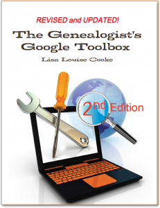
And if you need help figuring out how to effectively Google search, I have a book for that!The Genealogist’s Google Toolbox–the ultimate guide to using all of Google, including a full chapter on Google Books.
PDF – I Love You!
Many white-papers, scholarly works, and quick reference guides come in PDF format, and they upload like a breeze.
PDFs are so versatile, and they play ever-so-nicely with Google Play Books. It’s just another reason to love your Google Books library.
Stock Your Google Books Library
Are you feeling like your Google Books Library has room to fill? All of our quick reference guides are easy-to-upload PDFs, and all of the following genealogy resources are available as digital downloads in the Genealogy Gems store:
For a hand-picked list of novels and other great leisure reading for genealogy lovers, visit the Genealogy Gems Book Club page. I know you’re going to love our suggested best-sellers and best-kept-secrets about family, the search for identity, and fascinating stories in history.
You can now see New York City street views from the late 1800s and early 1900s as Google Earth street views. Take a virtual visit to the Big Apple as it was 100 years ago! Or travel back even further in time to an 1836 map of NYC conveniently overlaid on a modern Google Earth view. These are just two of the many ways to use Google Earth for genealogy—and for fun.
Vintage New York City Street Views on Google Earth
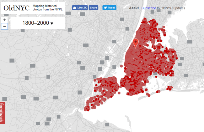
Over 80,000 original photos from the late 1800s and early 1900s have been mapped into Google Earth to provide what’s essentially a Google Street View map of old New York City!
As you can see from this overview map (below), the old photos are concentrated in the areas of Staten Island, Brooklyn, Queens and Lower and Upper Manhattan. Dots represents historic photos that have been overlaid on Google Earth’s modern map (satellite view is also available).
Old NYC
You can zoom in to click on individual dots, which will bring up one or more individual photos of certain neighborhoods or street fronts:
Select the photos that match up best with your family history interests, such as a shot of your family’s old store front or apartment building. Or choose images that represent the time period in which your relatives lived in the area, so you can get a flavor of what their neighborhood would have looked like. (Click here for some ideas about where to look for your family’s exact address during the late 1800s or early 1900s.)
According to this article at BusinessInsider.com, a developer Dan Vanderkam worked with the New York Public Library to plot all the photos onto Google Earth. (A hat-tip to Genealogy Gems listener and reader Jennifer, who sent me this article because she knows how much I love old maps and data visualization!)
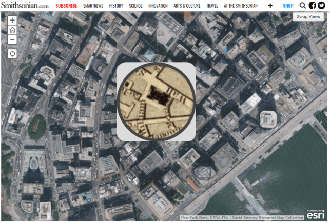
Another Old NYC Street View: 1836 Map
While we’re on the subject, I also want to mention another cool tool for visualizing old NYC street views. At the Smithsonian.com, there’s a cool historic map overlay of an 1836 New York City map in Google Earth. Use the scrolling and zooming tools to explore the parts of NYC that were already settled–and to compare them to what’s there today. You can also swap views to see the 1836 map with just a little round window of the modern streets.
The accompanying article quotes famous map collector David Rumsey about the 1836 map, which is his. He describes how you can see that much of the topography of Manhattan has changed over the years—did you know Manhattan used to be hilly? And I love how he calls out artistic features on the old map, too.
Smithsonian NYC street view 1836
Unfortunately, the old map doesn’t show much in the way of residents’ property lines or buildings. But you can clearly see the street layouts and where the parks and hills were. Comparing these areas with Google Earth’s street view today can help you better understand what things looked like in a much older version of one of the world’s great cities.
Use Google Earth for Your Genealogy
There are so many ways to use Google Earth for genealogy! My free video class will get you started. After a quick tutorial on downloading and navigating Google Earth, see how to utilize its powerful tools to identify an old family photo, map out addresses that may have changed and even plot an old ancestral homestead.
Live show air date: June 25, 2020
Join me for Elevenses with Lisa, the online video series where we take a break, visit and learn about genealogy and family history.
The first 4 minutes of the video is the “Waiting Room.” This welcomes viewers and counts down to the start of the live show.
Today’s Topic: How to get better Google search results faster.
Our Goal: Up to 90% reduction in the number of search results, and higher quality results on the first few pages.
In this session we discussed:
Identifying what you already have, (the “searchables”) and
using Google Tools to flesh out the details
so that we can tell a richer, more complete story.
Start broad and then analyze your results to determine if you need to narrow your search by adding more details and search operators.
Reviewing your initial search results will possibly reveal alternative spellings you may want to explore.
The search operator we used in this episode was quotation marks.
Example: “Washington McClellan”
Quotation marks can be used on single words or phrases. They tell Google that:
all search results must include in word or phrase,
the words must be spelled exactly as you spelled them,
the words in phrases must appear in the order your typed them.
You can have multiple words and phrases in your query.
Example: “mcalister” “harness” shop “logan utah”
If you discover an address during your searching, you can plot it in Google Earth. Search for it in the search box. Click the placemark button in the toolbar (the yellow pushpin icon) to mark the location.
(Learn more about using Google Earth in episode 12 of Elevenses with Lisa available here.)
Time Saving Tips:
When reviewing large webpages, quickly find your keywords (“searchables”) by doing a Find on Page: Control (PC) or Command (Mac) + F. Type the words in the pop-up box to jump directly to them on the page.
On the search results page, click Image results in the menu. This allows you to quickly spot sites with images that appear to be applicable to your search goal. Click the image to visit the site.
Use the quotations marks search operator in all of the free Google tools.
Learn More with These Resources
Book: Cooke, Lisa Louise, The Genealogist’s Google Toolbox, Genealogy Gems Publications, print. Video Series: Cooke, Lisa Louise, Google Earth for Genealogy digital video download series, Genealogy Gems Publications, For a limited time use coupon code EARTH11 to get 25% off both of the resources above at the Genealogy Gems Store here.
Use code EARTH11 to get 25% off
Answers to Your Questions
Gwynn: If I have a My Google Map and pin on those will they show up on the google maps desktop version or do I have to redo them? For example, I have a map of Ohio with ancestor dates and locations.
Lisa: Google has recently added a button to the toolbar that will take you to Google Earth on Chrome. So, if you are looking at your placemark on the map and you click that button, it will open the same general location in Chrome, but currently it will not bring the placemark with it. I would not be surprised at all though if we see that functionality in the future.
Ceirra: I played with Google Earth from last week but couldn’t get back to even 1937???
Lisa: If you mean there were no Rumsey Maps (in the Layers panel) in a particular area, that’s not uncommon. That’s where pulling maps from other sources like the David Rumsey website can help. He has 100,000 maps digitized, searchable and downloadable that you can then use to create an overlay in Google Earth. And there are many, many other online sources for old maps. Read: The Best Way to Find Old Maps for Genealogy at the David Rumsey Website
Cynthia: If we have something from our relatives, what is the best way to put it on the internet to share with others?
Lisa: I really think posting on your own blog is the best way to share. It also provides a vehicle for being found by other researchers interested in your family when they Google. I have videos on the Genealogy Gems YouTube channel explaining how to set up a free Blogger blog.
MargtheCar: Are quotation marks case sensitive?
Lisa: No.
Steve: If you had two different spellings of a name, do you run separate searches for put both spellings in one search?
Lisa: You could run this search: “washington mcclellan” OR “Washington mcclelland”
Kelli: I ordered google toolbox 3. I have the first two. Are they worth sharing – or have things changed enough that I should just toss them? Shelf space, you know :).
Lisa: They are worth sharing if you warn them may encounter some things that no longer work or have changed. Search has some of the biggest changes. The Google Earth section hasn’t changed much since the last edition of the book.
K M Vaughan: Can we legally use the image from the library?
Lisa: Check the website for terms of use, or contact the library for permission.
Gwynn: Lisa, what do you think of the new google books viewer, Im not a fan because I cant see the source.
Lisa: It takes getting used to, I agree! But I think the overview page is actually quite an improvement. I’m publishing a newly updated version of my class Google Books: the Tool I Use Every Day in Premium membership that features the new viewer.
Karen: Can you use – minus?
Lisa: Yes indeed. Here’s an example of combining quotation marks and minus sign in the same query: “Richard Lincoln” -abraham – president
Robyn: I don’t find that the 1850..1880 works for me. What could I be doing wrong
Lisa: Problems could include:
Running the search on mobile
You have a space in the string – no spaces
There are no available results that include those numbers
Using more or less than 2 periods
K M Vaughan: Can your Google tools on mobile
Lisa: Yes, all the tools (such as Google Books, Scholar, Patents, etc.) can all be used on mobile, however you may find some minor differences, and some search operators may not work.
Cynthia: I have been trying to find the marriage certificate of my grandmother and her 3 husband, in 1953 and cannot find anything. What can I do to marrow the search
Lisa: Without the benefit of seeing the specific situation, I would recommend focusing your search on the record collection you need rather than the names of individual ancestors. I go into detail on this strategy in the book.
Carolyn: What did you use to make the video?
Lisa: I used Camtasia which I LOVE. Stay tuned, because next week we’re going to talk about making videos and some of the my favorite free tools as well.
Doug: What tool do you use to create the entries in Google Earth for the presentation (the autoplay part)?
From Lisa: I used Camtasia. Stay tuned, because next week we’re going to talk about making videos!
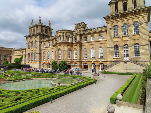
Blenheim Palace Grand Cabinet china. Learn more about Blenheim Palace, the home of Winston Churchill, at the website.
Garden-side tea time at Blenheim Palace
From You
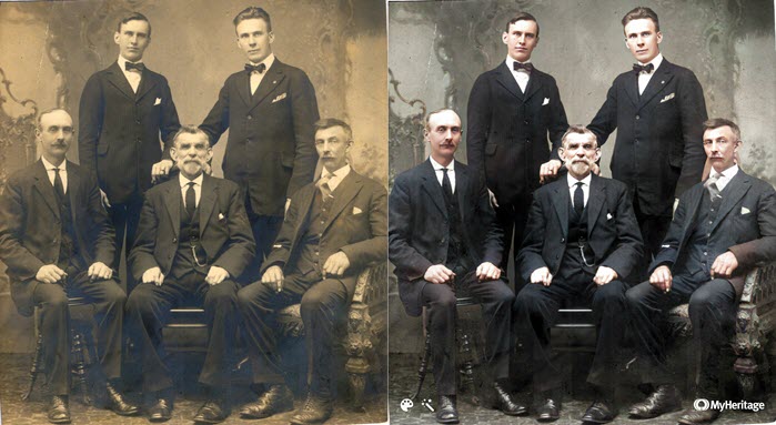
The best part about teaching is when I get to hear back from you about what resonated with you, and how you used what you heard to make a wonderful discovery. Doris has been a Genealogy Gems premium member since 2015 and she wrote to say “I’m finally listening to the Elevenses series! Just watched Episode 1 and wanted to share a find.”
Doris explained how she used my tip on being sure to turn the page of passport application records to ensure you don’t miss additional pages. She made quite a discovery!
Thank you to Doris for sharing her story. I sent her the video I created and the photo that I enhanced and colorized at MyHeritage.
Please give our videos a thumbs up at YouTube: As a friend of the show, will you please give the videos a thumbs up (you’ll find the icon just below each video) and leave a comment? Your input makes a huge difference in encouraging YouTube to distribute the show – and it warms my heart too, thank you!
Did you give this Google search operator a try in your genealogy searching this week? Please share your experience. And of course I’m always interested in your questions and feedback. Please leave a comment below. This is your chance to join our community’s conversation!
(Update 2020) When genealogists take an ancestry DNA test, they are looking for more than just their ethnicity results. They are also very interested in receiving information on other people who have tested who closely genetically match them. They want to know who the closest matches are, and if those matches have family tree information that they can share.
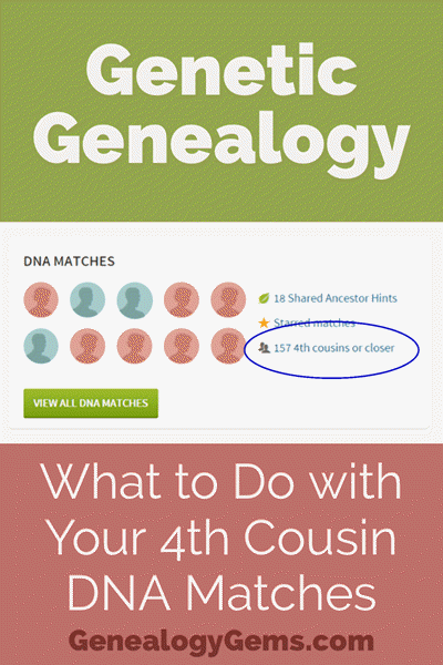
However, with all the people testing these days, (some being genealogists and some not) the volume of matches can become overwhelming very quickly.
Are you one of those people who have way too many genetic “4th cousins or closer” among your DNA matches? Have you ever wondered “What do I do with all these matches?!” If so, keep reading. We’re going to explore some of your options, and most importantly, how to determine how genetically close your cousins really are.
Doing the DNA Math on Your Cousins
Math can provide us with a degree of certainty in genetic genealogy. Each of us has two biological parents. We have four biological grandparents, and eight great-grandparents.
However, the farther back we go the less we can rely on math.
For example, on paper you should have sixty-four 3rd great grandparents. However, many of us find that the same person occupies more than one slot on our pedigree chart. While this significantly decreases the workload for traditional genealogy, it adversely impacts your genetic genealogy. Especially when it comes to that long long list of 4th cousins you have in your match list at any of the three major DNA testing companies.
Depending on how intermarried your lines are, you may be seeing individuals on your match list that genetically look like your fourth cousins, but they are genealogically your sixth cousins – EIGHT TIMES! So how can you tell the difference?
There are two parts to that answer: one you can control, and the other you can’t.
Distinguishing DNA Matches with Genetic Tools
While your fourth cousins and your eight-time-sixth cousins may look similar genetically, there are often small clues in the genetics that can help you tell the difference. This distinction can sometimes be detected by a testing company who, through research and validation, has been able to fine-tune their algorithms to detect these subtle differences.
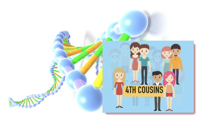
Your Genetic 4th Cousins
You can participate in this double checking process by using some of the genetic tools that are available to you at Family Tree DNA, or at Gedmatch.com. But since you may not be an aspiring geneticist, let’s focus on the genealogical work you can do to determine if a match is truly a fourth cousin.
Use Google Earth to Plot Your DNA Matches
A fourth cousin designation just means that you and your match are separated by between six and twelve degrees (people). So that might be five back on your chart to your common ancestor, and five down to your match, which would make you true fourth cousins. It could also be some other permutation of that.
For our example, let’s assume true fourth cousins. That means that the two of you share one of thirty-two 3rd great grandparents (16 couples). In order to find out which set, you have two genealogical identifiers: surname and location.
Therefore, the first thing you should do is make a list of the surnames and locations of those thirty-two 3X great grandparents.
Now, most of us do not know all 16 of those couples, so you are going to have some holes. Feel free to fill in those holes with surnames on subsequent generations that will carry through to this fifth generation.
A great tool to plot your own list of ancestors geographically is the free downloadable Google Earth software.
Check to see if you have the latest version of Google Earth downloaded to your desktop or laptop computer. On your desktop, look for a grey and white globe. If you see a blue and white globe, you have the older original free version of Google Earth. However, a few years ago, Google made their Google Earth Pro version free to everyone, and it is now the standard.
If you do have Google Earth Pro (the grey globe software) then you’re ready to go.
The grey Google Earth globe on the desktop.
If you don’t have it, then you will need to download it.
If you agree to them, click the Agree and Download button
Follow the installation guide
When complete click Run Google Earth
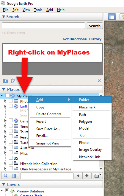
Now that you have Google Earth, you can begin by creating a folder in the Places panel in Google Earth devoted to your 16 couples. Here’s how:
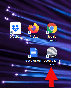
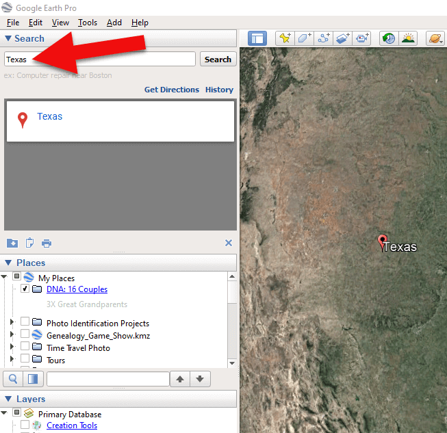
1. In the Places panel, right-click on MyPlaces and select Add > Folder:
Right-click on MyPlaces > Add > Folder
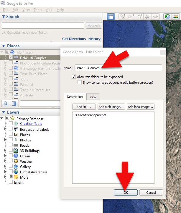
2. Name the folder and then click OK:
Creating a folder in Google Earth
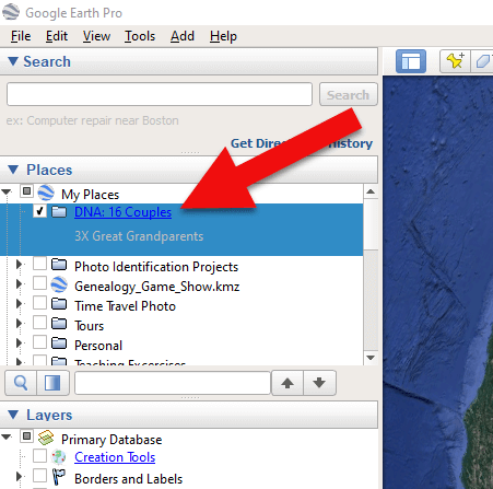
3. Now you will see your new DNA folder for your 16 couples in the Places panel. If you don’t see it, look toward the bottom of the list. You can move the folder to any location within the list by dragging and dropping it.
Create a folder in Google Earth for DNA 16 couples
Once you have your DNA folder created fro your 16 couples, you can then easily plot your surnames and locations.
How to Plot Your Surnames and Locations in Google Earth:
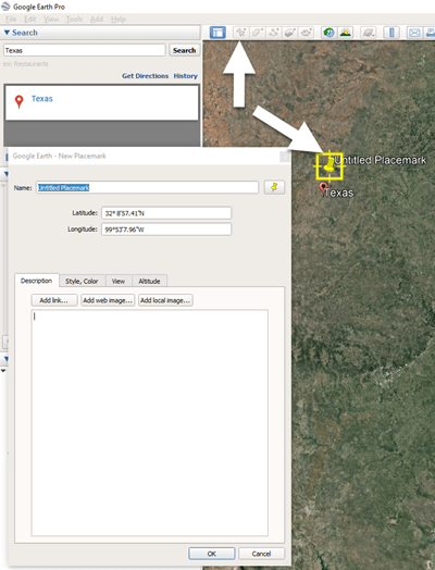
1. Click your new DNA folder to select it. This will ensure that the placemark you are about to create will be stored in that folder.
2. In the search box (upper left corner of the Google Earth software) type in the first location and click Search. Google Earth will fly to that location on the map.
Type the locaton in the Search box and click Search.
3. In the toolbar along the top of the screen, click the placemark button to place a pushpin in that location:
Click the Placemark button in the Google Earth toolbar.
4. In the Placemark dialogue box, enter a title for hte pushpin placemark. Click the OK button to close the box and set your placemark.
5. Repeat the process for all the locations.
Then evaluate the fifth generation of your fourth cousin matches for genealogical information that lines up with any of the items on your list.
You can also plot the surnames and locations of your matches in Google Earth. This is where Google Earth really comes in handy. The free software makes it very easy to see when your ancestral home may be bordering the locations of your matches. Those with whom you find a similarity become your best matches, and your best chance of determining your connection. Those without an obvious connection cycle to the bottom of your pile for a genetic evaluation. You can perform these same kinds of searches for your second and third cousins as well.
As you begin to become more familiar with the fifth generations of your matches, you may also start to see patterns of surnames or locations emerge among your matches. These then become the surnames and locations that might be able to fill the missing spaces in your pedigree chart.
More Genetic Genealogy and Google Earth Gems
If you are new to using Google Earth, I have several suggested resources for you by Lisa Louise Cooke:
If you are a Genealogy Gems Premium member, Tune in to Genealogy Gems Premium podcast, episode 131, for tips on how to run a more thorough genetic evaluation on those 4th cousin matches.
Here’s a video of the authors discussing three common DNA misconceptions:
 eBooks come in several different formats. While I’m not covering in this article how to convert file types or deal with DRM protected books, there are resources available to help you do so.