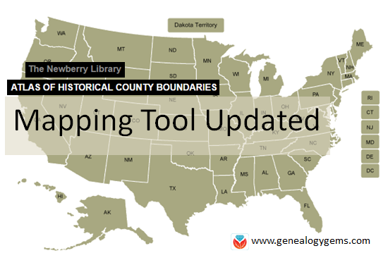
The Newberry Library’s online Atlas of Historical County Boundaries is finally fully updated and interactive! Read the good news here–and my preference for using the powerful geographic data that drives the Atlas.
The Atlas of Historical County Boundaries at The Newberry Library’s website has been undergoing upgrades for quite some time. Genealogists who rely on this fantastic online resource to research old county boundaries in the U.S. have been able to access the basic data that drives the map (dates and geographic boundary changes). But they haven’t been able to use the popular interactive map. Great news: the Atlas is finally fully interactive again.
Changing Boundaries Reflected in the Atlas of Historical County Boundaries
Understanding changes in county boundaries over time is key to doing genealogy research in the United States. Boundaries have changed repeatedly–and some dramatically. County governments typically keep important genealogical sources: vital records, court records, land records and more. We need to know which county would have housed our ancestors’ records during specific time periods so we can find the records we want.
What’s New at the Atlas of Historical County Boundaries
According to the Newberry Library’s press release, users can now:
view a base layer map that allows an overlay of boundaries on top of cities, towns and other geographic features;
zoom in and out of maps and expand the view to full screen;
select a date of interest from a drop-down box with all border change dates for that state; and
view information about border changes in a hover box that changes as users hover over different counties.
Here’s what the new interface looks like:
Google Earth Pro vs. the Atlas of Historical County Boundaries
It’s great to see improved functionality on the Atlas site. But after reviewing the update, I still think the experience of using data from the site is superior in the free Google Earth Pro (GEP) program. To use the entire data set in Google Earth Pro, simply download the KMZ data file onto your computer,and when you click to open the file, your computer will detect the KMZ format and know to automatically open Google Earth Pro (as long as you already have GEP installed on your computer.)
Using the file in GEP allows you to use the data in conjunction with the rest of your genealogical information (such as placemarks indiciating places lived & schools attended, historic map overlays, embedded old family photos and home movies, etc.). This provides a more integrated genealogical research experience. Learn more by clicking here to watch a free video I’ve made about using Google Earth for genealogy.
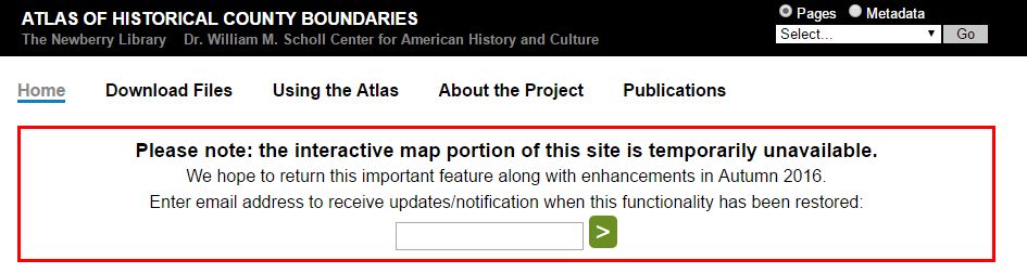
The online Atlas of Historical County Boundaries is a go-to resource for determining old U.S. county boundaries. Its popular, interactive map will re-launch later this fall. Meanwhile, you can still access county boundary data and even Google Earth compatible maps.
The first time I saw this message, I panicked. This is my favorite resource for quickly researching historical county boundaries in the U.S. The interactive map feature lets you click on a state and then on a county to see its boundaries on any exact date. I realized the rich data that feeds the interactive map is still there and you can still get to it.
Several months later, I noticed the out of order message was still there. I emailed the Newberry Library in Chicago which hosts the Atlas to see what they could share with Genealogy Gems about the Atlas and its future.
Curator Matt Rutherford replied right away: “We love Genealogy Gems! It’s such an excellent podcast.” (Lisa says “Thanks! We love you, too!”)
He explained that the online Atlas was originally meant to serve a small group of historians. When the interactive map’s code became outdated, the thought was to just let it die. He credits genealogists with giving it a future.
“Newberry heard loudly and clearly from the genealogy community about their love for the online Atlas,” says Matt. “It is because of the popularity of the Atlas among genealogists and due to Newberry’s commitment to serving the genealogy community that [we’ve] decided to dedicate resources to the interactive map’s redevelopment.”
When will the interactive map be back? “We do anticipate a launch in the fall, but we don’t have an exact date yet,” he says. “It takes time and funding to redevelop an interactive tool that is as data-rich as the Atlas. Once we got ‘under the hood,’ we realized that the redevelopment needed to be more extensive than originally anticipated.” (Genealogy Gems Premium website members can hear the full scoop from Matt in the Genealogy Gems Premium Podcast episode #137.)
How to find county boundaries with the Atlas of Historical County Boundaries in three steps
1. From the Atlas home page, click on the state of interest from the national interactive map.
2. From the state page, click on View Index of Counties and Equivalents. This will show you all current and past county names. (See image.)
3. From this page, click on your targeted county. You’ll find a timeline of that county’s boundary changes.
Use the timeline to discover what county your ancestors belonged to at any given time. Perhaps you’ll discover you should actually be looking for an ancestor’s marriage record or probate in a parent county, one that existed there before the current county, or in a successor county later carved out of this one.
Google Earth Bonus: The Atlas of Historical Boundary Changes state pages include downloadable maps compatible with Google Earth and Google Maps. If you are not using Google Earth for genealogy yet, watch Lisa Louise Cooke’s free video to see how and why you want to use this amazing 3D map of the world for your family history!
Time-lapse videos first intrigued me as a child when I watched a little seed grow into a beautiful flower in a matter of seconds. Now, illuminating time-lapse videos and tools are helping genealogists visualize our changing world.
Last month, animator Max Galka published a time-lapse map of the history of urbanization over nearly 6,000 years in just three minutes.
Mr. Galka mentions on his blog that tracking urbanization occuring before the mid-20th century was a difficult task – until recently. A team of Yale researchers published a collection of urban population data dating back to ancient times which helped Galka create his video. Their collection was quoted to be a “clean, accessible dataset of cities, their locations, and their populations over time.”
I was surprised how quickly things changed and found it amazing still how many places in the world are yet to be “urbanized.”
Time-lapse Video Covering Immigration to the U.S. Since 1820
Again, Max Galka presented an amazing animation of immigration to the United States. This creation shows the countries that sent the most people to the U.S. since 1820.
The U.S. is a nation of immigrants, says Galka. As each dot flies across the page, it represents 10,000 people who immigrated to the U.S. In the bottom left corner, Mr. Galka lists the three top countries where immigrants are coming from at any given time. I was stunned as the map lit up in Russia and Africa only fairly recently. It is clearly shown that the U.S. is indeed a nation of immigrants in this colorful time-lapse video.
Time-lapse Tools for Genealogy
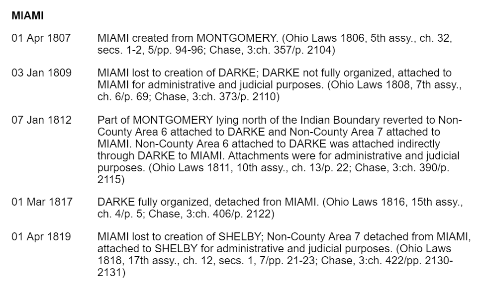
As a genealogist, I am constantly in search of county records. So many times, county lines or boundaries changed. I even have one family that lived on the same farm, but technically resided in three different counties over a period of about 50 years. We can’t possibly know when each county of any given state was formed or created, until now that is.
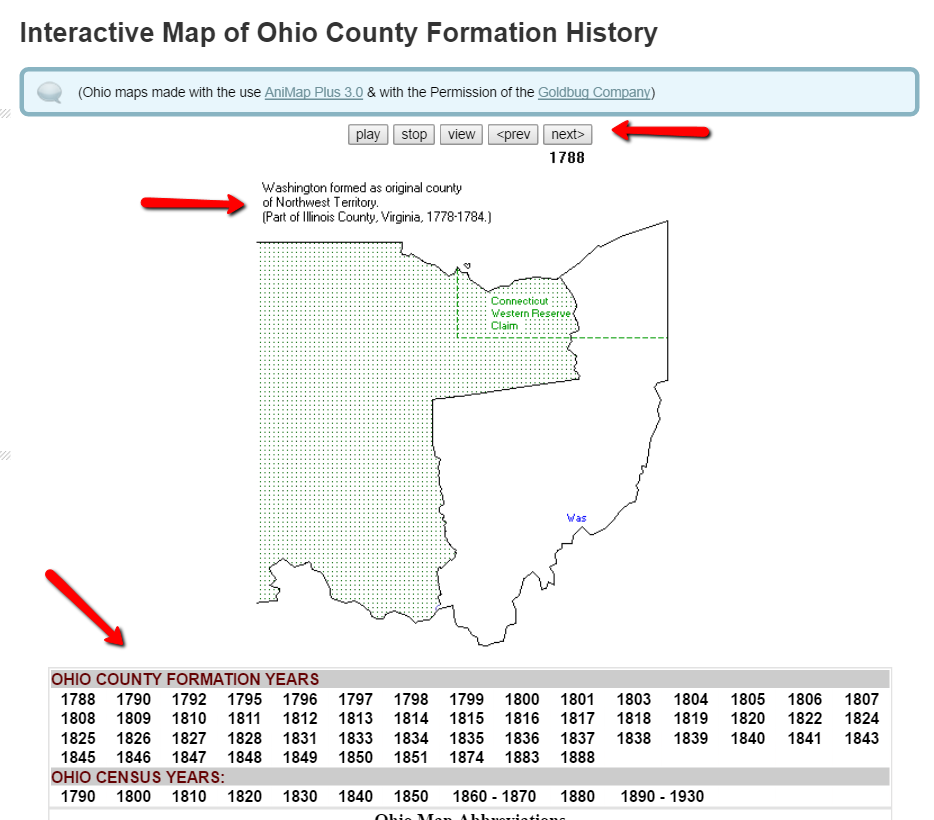
One of my favorite tools for discovering county changes over time is the Map of US.org website. You can find a map of each of the 50 states and run the interactive formation sequence. For example, I can find the Ohio map.
The Ohio map begins in 1788. It indicates the one county in the Northwest Territory (today’s Ohio) at that time. Washington County was formed as the original county of the Northwest Territory and was created from part of Illinois County, Virginia. That’s another reason I love these interactive maps. With the creation of each county, the map indicates from which parent county or counties it was formed. This is a great help for genealogy research. When I can’t find my targeted ancestor in the county I thought they should be in, I can determine when the county was formed and from what parent county or counties it was formed from. Then, I can quickly determine the other locations that may have records I need.
In addition to the interactive time-lapse maps, each state has a list of other helpful maps that may be of interest to you. For example, the map links for Oregon include the Historical Maps of Oregon, a set of beautiful old maps that can be viewed or downloaded.
Maps can give us a bigger picture of our county, our state, our country, and even the world. These tools help us picture our ever-changing world. What impacted you the most while watching these videos? We would love to hear from you in the comments below!
If you feel inspired to learn more about map visualization, you will enjoy Lisa’s Google Earth video. Lisa was an early pioneer of genealogical data visualization and has been teaching genealogists how to use the free software for the last several years. You can watch the free Google Earth for Genealogy video here or check out her revised and updated e-book, The Genealogist’s Google Toolbox 2nd Editionto learn even more tips and tricks for Google genealogy research.
 The Atlas of Historical County Boundaries at The Newberry Library’s website has been undergoing upgrades for quite some time. Genealogists who rely on this fantastic online resource to research old county boundaries in the U.S. have been able to access the basic data that drives the map (dates and geographic boundary changes). But they haven’t been able to use the popular interactive map. Great news: the Atlas is finally fully interactive again.
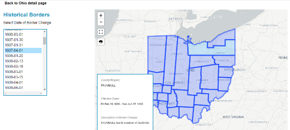


 “Newberry heard loudly and clearly from the genealogy community about their love for the online Atlas,” says Matt. “It is because of the popularity of the Atlas among genealogists and due to Newberry’s commitment to serving the genealogy community that [we’ve] decided to dedicate resources to the interactive map’s redevelopment.”