by Lisa Cooke | Nov 19, 2015 | 01 What's New, Blogs, Google Earth
 Lisa Louise Cooke’s free Google Earth for Genealogy online video is so popular, the announcement about it was our #4 genealogy blog post for the year! Guess what? The online video is still there–and it’s still free.
Google Earth is one of Google’s most powerful tools for helping us understanding our ancestor’s world. (And if you read our #6 top post about other Google technologies you can use for genealogy, you know that’s saying something!)
With Google Earth, we can use satellite imagery, terrain maps, 3-D views of city streets and even overlays of old maps to learn about an ancestor’s town, neighborhood and even the very property they lived on. Even better, as Lisa demonstrates in her free video, we can also use Google Earth to share those discoveries with others in multimedia style.
Click here to “fly” (as Google Earth would say) to Lisa’s FREE Google Earth for Genealogy class!
We hope you are enjoying this week’s celebration of our Top 10 blog posts. Don’t forget about our countdown prize this week! Click here to see all Top 10 posts on our genealogy blog–and share that post on your Facebook page by THIS Friday (November 20, 2015). Use the hashtag #genealogygems, and you’ll be entered in a contest to win my Pain Free Family History Writing Project video course download, donated by our friends at Family Tree University. Add any comments you’d like on your “shared” post, like which Genealogy Gems blog post has most inspired you or helped your research. That feedback helps us bring you more posts you’ll love.
 Ready, set, SHARE! And thank YOU for helping us celebrate our 1000th blog post here at Genealogy Gems.
by Lisa Cooke | Jul 15, 2015 | 01 What's New, Google Earth, images, Inspiration, Maps, Photographs, United States

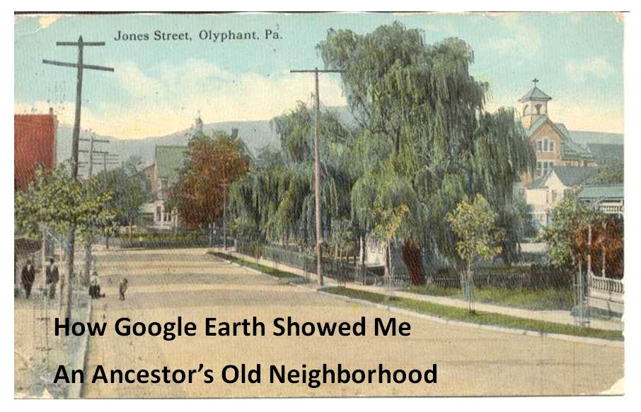
Jones Street, Olyphant, PA, 1910. Image courtesy of Michael Grayson.
When Lisa blogged recently about Google Earth’s 10th birthday, it reminded me of something on my family history “to do” list. A few years ago I found a postcard of what I thought was an ancestor’s neighborhood. Could Google Earth confirm it?
Lisa uses Google Earth’s powerful 3D renderings of the world’s streets to identify where old pictures were taken. I knew from deeds, a plat map, and addresses on censuses and draft registrations that the O’Hotnicky lived on a certain block of Jones St. (now named Grant St.), around the corner from and behind Holy Ghost church.
This postcard of “Jones Street, Olyphant” looks like its viewpoint is from the end of the block behind the church. This would mean the tall tree shown here was shading–and blocking our view of–the O’Hotnicky home.
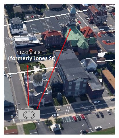
 I opened Google Earth and flew to “117 Grant St, Olyphant, PA.” The initial view, hovering from above, was promising. The camera icon shows where I thought the photo was taken. The left arrow points to the former line of trees, in front of the ancestral address. The right arrow points to the church tower behind.
Unfortunately, when I enter Street View at that exact spot, the new church on the corner and a tall apartment building block the view that would have been seen a century ago. There is no Street View available on Grant Street itself so I couldn’t move up the street toward the church. So I moved into Street View along the side street (parallel to the bottom of the photo).
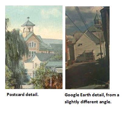
In the opening between two buildings, Google Earth gave me a glimpse of the church tower. I compared the postcard view with Google Earth’s photo. The church towers look so similar: a simple cross on top, pointed copper roof, arched tower and the building roof line. Even more striking to me is the white frame house. Was this the same white house shown in the postcard view?
These two visuals taken together–the church tower profile and the position of the white house–seem consistent with my theory of where the photo was taken. Which means that yes, indeed, this 1910 postcard shows the trees in front of an ancestor’s home as they appeared 105 years ago.
Google Earth can fly you to an ancestor’s neighborhood–and whatever clues its current landscape gives you into the landscape of the past. Click here to watch Lisa’s free video about using Google Earth for genealogy!
by Lisa Cooke | Jul 11, 2015 | 01 What's New, Google Earth, images, Maps
 Ten years ago in June, Google Earth was born. The world put it right to work. Within months, recalls a Google Earth employee, “Hurricane Katrina showed us how useful mapping tools like Earth could be for crisis response efforts. Rescue workers compared before and after Satellite imagery in Google Earth to better locate where people were stranded.”
“In the years after,” the blog post continues, “with more than 2 billion downloads by people in nearly every country in the world, Earth has enabled people to discover new coral reefs, journey to the Moon and into deep space, find long-lost parents, clear landmines and much more.”
What about YOU? How have you harnessed the power of Google Earth for good?
What about using Google Earth for genealogy?
 In honor of Google Earth’s birthday, we invite you to watch a free video recording of a special presentation of Google Earth for Genealogy! Check out these blog posts, too:
 Ready to take Google Earth to the next level? Pick up your copies of the video CD series Google Earth for Genealogy at the Genealogy Gems Store.
by Lisa Cooke | Mar 26, 2015 | 01 What's New, Cemeteries, Google Earth, Maps
Do you ever wish there was a master map of all the cemeteries in the world? While there isn’t one map that includes every single public and private cemetery around the world, the free software program Google earth offers up something close. Here’s what you need to know about how to find cemeteries in Google Earth.
Lisa Louise Cooke: teaching Google Earth for Genealogy since 2007.
These days Google Earth is a free software program, a web-based program and a mobile app. Each form of the application has it’s own merits, and today we’re going to explore one of the software’s best features: the ability to map out cemeteries around the world, and gather valuable information about them. This feature is particularly useful for the family historian who wants to learn more about their ancestors, including where they are buried.
But before we get started, you need to check to see if you have the latest version of Google Earth downloaded to your desktop or laptop computer. On your desktop, look for a grey and white globe. If you see a blue and white globe, you have the older original free version of Google Earth. However, a few years ago, Google made their Google Earth Pro version free to everyone, and it is now the standard.
If you do have Google Earth Pro (the grey globe software) then you’re ready to go.
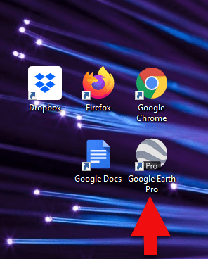
The grey Google Earth globe on the desktop.
If you don’t have it, then you will need to download it.
How to Download the Free Google Earth Software:
- Go to http://www.google.com/earth/download/gep/agree.html
- Click the blue download button
- Read the Terms and Conditions
- If you agree to them, click the Agree and Download button
- Follow the installation guide
- When complete click Run Google Earth
Now that you have Google Earth on your computer, launch it and look on the lower left side of the screen. There you will find the Layers panel.
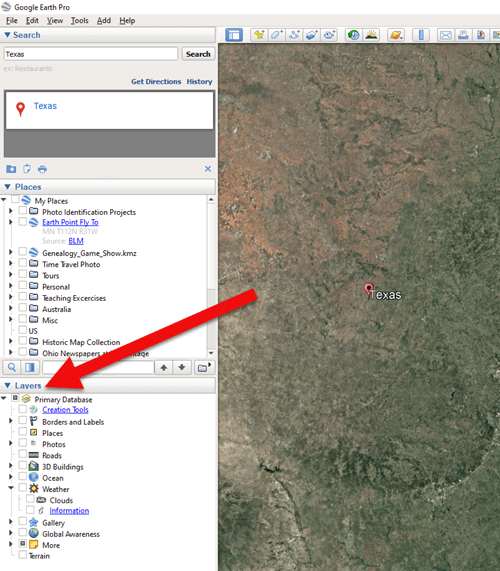
The Layers Panel in Google Earth.
Google Earth Layers are collections of points of geographic interest that have been curated by Google Earth or its content partners. When you click on a Layer, it brings up all those points of interest on your current view of Google Earth.
You’ll find the Layers panel on the bottom left side of your screen. To display all points of interest within a Layer, click the box next to the Layer title. To open a Layer category, click the plus sign next to the label to open the Layer folder, and the minus sign to close it.
There are lots of genealogically-interesting Layers, including Cemeteries. You will find Cemeteries in the More > Place Categories > Places of Worship layer. Make sure the box next to Cemeteries is checked. You’ll see the little buy hiv medication online icon showing a tree with a little headstone next to it.
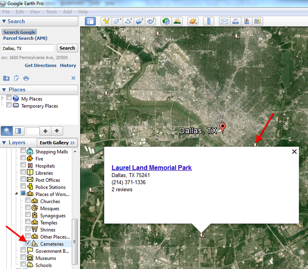
Next, search for a location in the Search box to “fly” to a neighborhood in Google Earth where you’d like to find nearby cemeteries. Look for those Cemetery icons. You may need to zoom in or out for them to appear. While not every cemetery is shown, it’s an excellent start!
Click on a cemetery icon. This will open a dialog box containing relevant information about the cemetery, often including the address and telephone number. If the cemetery title is hyperlinked, click it for even more useful information.
I hope you enjoyed learning how to find cemeteries in Google Earth. You can learn more about using Google Earth for genealogy in my book, The Genealogist’s Google Toolbox, Second Edition, fully-revised and brand new for 2015. It’s got five chapters devoted to how to use Google Earth for genealogy that are filled with more tips like this one.
And one more thing: did you know that Google Earth Pro is now available for free? Click here to read my post with all the details.
Happy Googling!
by Lisa Cooke | Feb 18, 2015 | 01 What's New, Google, Google Earth, images, Maps
 On January 28, 2015 Google announced that Google Earth PRO is now available for FREE! Not just a free trial. Google is allowing everyone to get a free key to Google Earth Pro!
In the past the software fee was hundreds of dollars. But now you can get Google Earth Pro for free and gain the ability to do things like “measure 3D buildings, print high-resolution images for presentations or reports, and record HD movies” inside Google Earth.To get your free key to Google Earth Pro sign up here. After submitting the form, you will be emailed the free license key. Copy the license key from the email, then click the link provided to download Google Earth Pro app for PC and Mac.
Everything I’ve taught you about using Google Earth still applies, but now you have more tools than ever!
Since I announced this in the last Genealogy Gems Newsletter, I’ve received several questions. Here’s what you need to know about Google Earth Pro:
From Sheri: “I did get it to finally work…..instead of my phone number running together….I added the dashes between the numbers and then it went through. FYI….in case you hear an issue from others.”
 Thanks for the tip Sheri. Most likely the problem you were running into after the big announcement that Google Earth Pro went free was the sheer amount of traffic the site received. Googlers swarmed the site, and any people found it took several attempts to get a successful download. As time passes, it should get quicker and easier to download.
From Kathy: “I downloaded the Google Earth Pro BUT now I have regular and Pro on my computer and all the spots marked in regular seemed to have transferred to Pro—Question—should I now uninstall the regular version?”
Answer: That decision is really up to you. I’ve decided to keep both for a while, but only do work from this point forward in Pro. If in a few months everything is still running smoothly, then I will probably delete the old free version just to free up disk space on my computer. For now, it certainly doesn’t hurt to leave it there.
The good news is that both programs appear to pull from the same files on your computer. This means that when you create a file in Pro, you will also see it in your Places panel in the free version.
Question from Dea: “I downloaded Google Earth Pro on my main computer. I now want to use the same license key for my laptop and android, as I signed up for 2 to 5 users. I assumed that I could use the same license key. When I tried to sign up on my laptop it said I already was a user, but do not know how I can access it from my laptop. Help!”
Answer: Although the sign up page asks how many users will be using the program, my understanding is that each download key is for one device. I would guess that the user question is about how many people might be using the application on that device. (Unfortunately the website isn’t clear on this point.) I’m basing this on the fact that when it was a paid version, you had to purchase a license key for each device.
As with the original free version of Google Earth, each device you download Google Earth to has it’s own unique Places Panel. In other words, files you create on your desktop computer don’t show up on your laptop. This is because the files are stored on that particular device and not on the Cloud (for privacy reasons).
So the bottom line is that to get another license key for another device you will need to use a different email. If you only have one email address, you could create a second free email in Gmail just to have an email you can use.
Dea’s Reply: “Thank you for such a prompt reply. I am sure there must be more than one of you. I do not know how you get so much accomplished….saw you at Midwest Roots in Indianapolis and, again, at a webinar for our Genealogy Society in Terre Haute, IN. You are an excellent speaker, teacher as well as entertaining.”
Lisa: Now I’m blushing!!
Answers to more questions:
Do you really need Google Earth Pro? Probably not, because Pro was created originally for businesses. However there are some pretty cool extras that you get by going Pro:
- Movie-Maker: Export Windows Media and QuickTime HD movies, up to 1,920×1,080-pixel resolution. (Sweet!)
- High-resolution printing: Print images up to 4,800 x 3,200 pixel resolution. (The free version max: 1,000 pixels.)
- Spreadsheet import: Ingest up to 2,500 addresses at a time, assigning place marks and style templates in bulk. (My geeky side is getting giddy!)
- Exclusive pro data layers: Demographics, parcels, and traffic count.
- Advanced measurements: Measure parking lots and land developments with polygon area measure, or determine affected radius with circle measure.
Resources:
Want to learn more about using Google Earth specifically for genealogy? Check out this free video class.
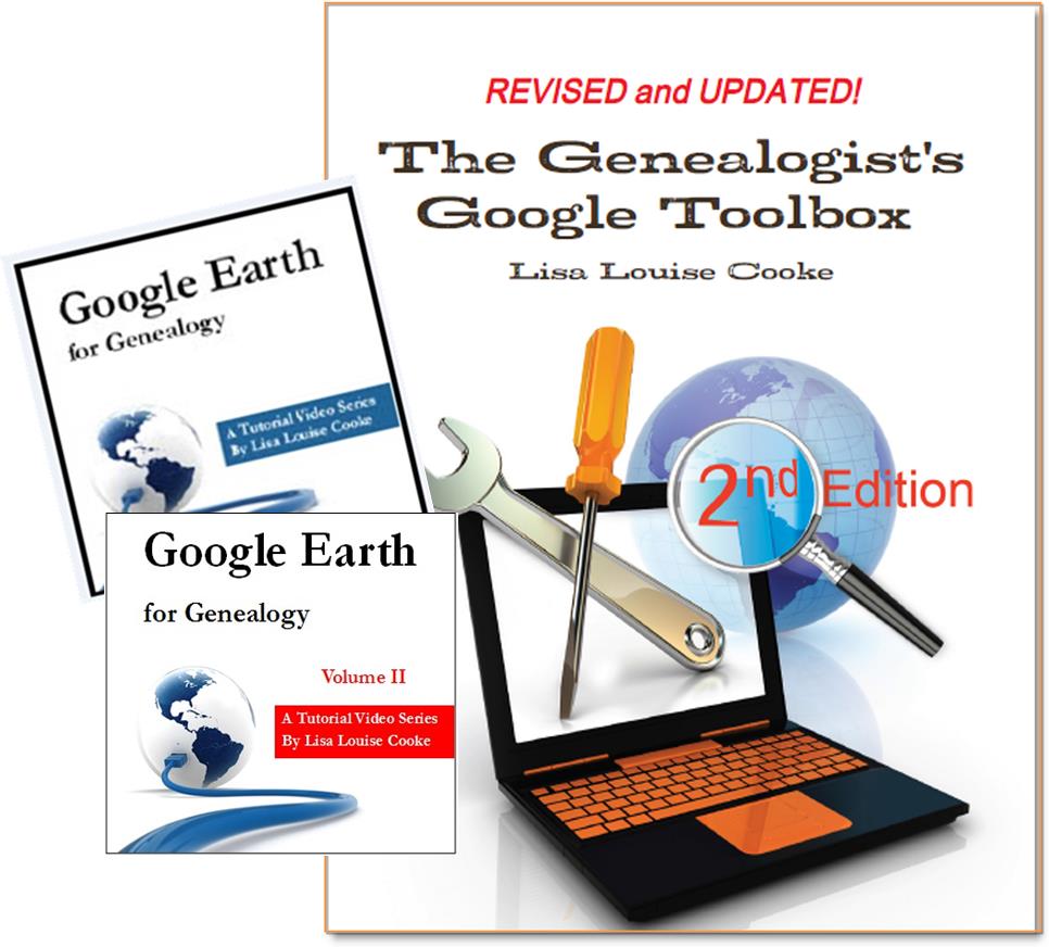 And there are several chapters on using Google Earth for genealogy in my brand new book The Genealogist’s Google Toolbox Second Edition (2015). You can pick up as a special bundle here with my 2 disc DVD set Google Earth for Genealogy.
Page 3 of 9«12345...»Last »