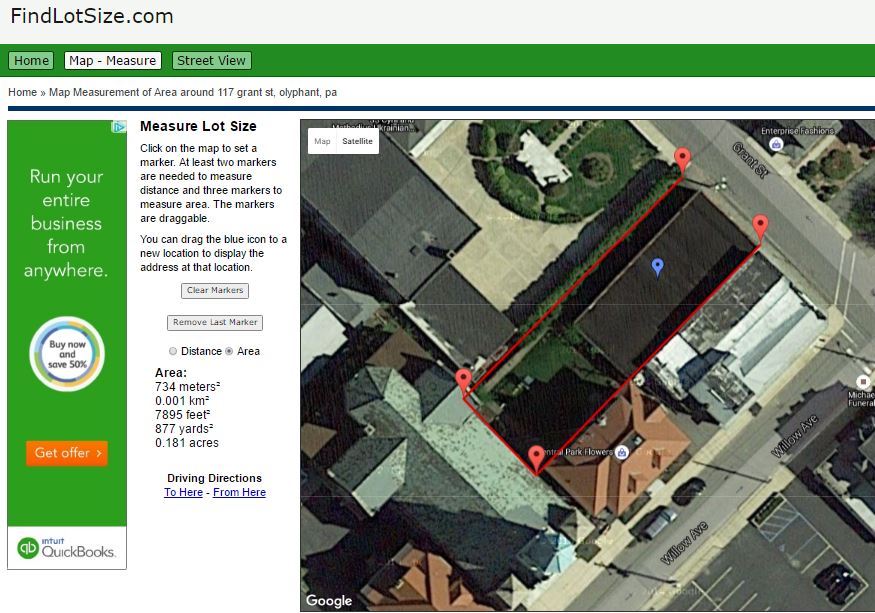
Use this free online tool to calculate lot size for an ancestor’s piece of property. The drawing tools overlaid on Google Maps help you determine the area of a lot and distances along its perimeter.
Researching a family piece of property can be tricky for several reasons. But there’s an easy and free tool you can use to help you calculate the size of an ancestor’s lot. It’s FindLotSize.com. This is what it looks like to use:
2. Enter a street address and click Go. (If you don’t know an exact street address, get as close as you can, then zoom around on the screen until you can see the property of interest.)
3. Zoom in (or out) to the level that you can see all the lot boundaries.
4. Click on one corner of the lot. A red marker will appear. Then click on the other corners in sequence to draw the perimeter. You don’t need to “close the gap” by clicking a second time on the starting point; the site will automatically assume you mean for the last point you enter to connect to the first. The site will calculate the lot size in square meters/kilometers, square feet/yards and acres.
Here are a couple more tips for using the site:
If you wish to know the distance around the perimeter, click Distance. (You can measure individual distances, such as the width of the lot at the back, by only clicking on the points between which you want to measure.)
In the upper left are options to view satellite or map images. The satellite view is a bird’s eye view of the land today. You’ll see fence lines, roads, hedges and other practical clues to property boundaries. But sometimes these are obscured by tree cover. If you click on “map,” you’ll see a simple line rendering, like a traditional map, but with many buildings outlined. Depending on the tree cover, you may find this view helpful.
It may not help with genealogy, but Google Maps just got a lot more fun!
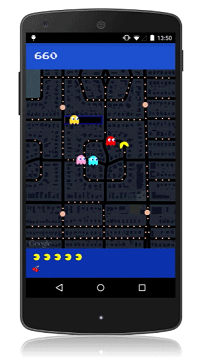
Yep, it’s PAC-Maps, and with this latest update you can find where NOT to go! Google has added imagery of “dangerous virtual beings, starting with Pinky, Blinky, Inky and Clyde. When navigating fruit-filled streets, determine at a glance which turns to pass to evade ghosts and get where you’re going safely. When you’re feeling a bit peckish, you can simply gobble up a few pac-dots or a cherry and keep on nommin’.”
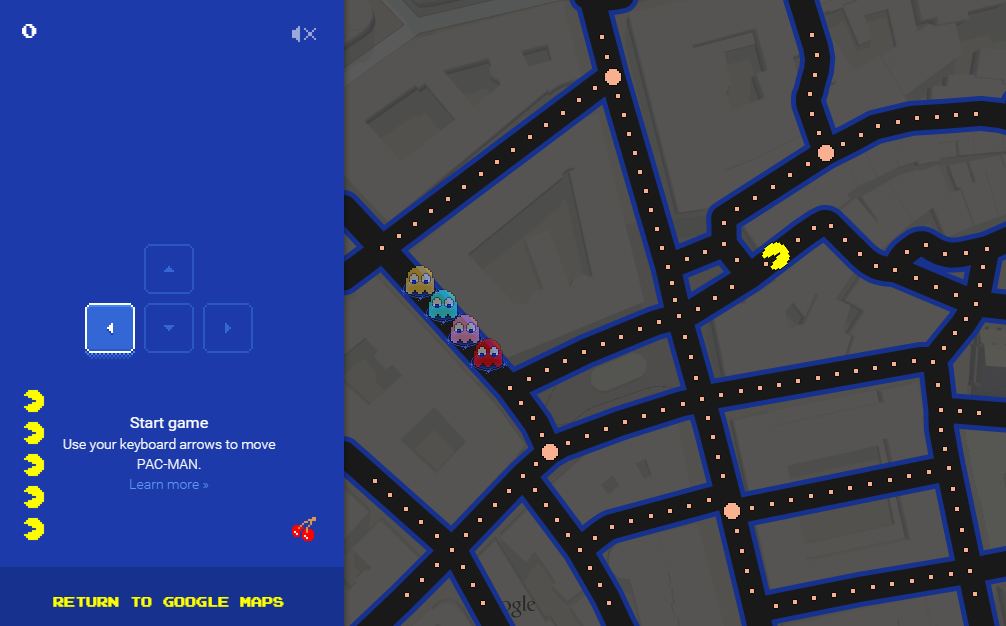
I’m a little embarrassed to say how many hours I spent playing PAC-MAN in high school. Back then we had to hunch over a machine located next to the bathrooms at the local pizza parlor. Now you can take a break from your brick walls and walka walka walka around the world from the comfort of your desk. With PAC-Maps you can navigate select locations using the left, right, up or down arrows on your keyboard. Below is a screen shot from the desktop version:
Actually, PAC-MAN isn’t new to Googlers. Back on May 21, 2010 (yep, it’s official, I’m a Google geek) Google’s home page featured a desktop version that you can still play here.
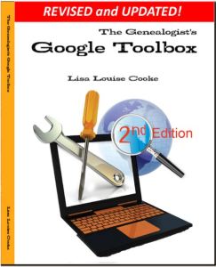
When you’re ready to head back to your genealogy brick wall, take my new book with you. The Genealogist’s Google Toolbox Second Edition makes Googling for your family tree easier than every!
Google Maps Street View was given an edge today over Google Earth’s street view when Google launched a “time travel” upgrade. The ability to time travel is high on most family historians list, and Street View imagery for Google Maps desktop provides a taste of that prize.
According to Google’s blog post today they have “gathered historical imagery from past Street View collections dating back to 2007 to create this digital time capsule of the world.”
Here’s an example of viewing Gettysburg with the new feature. In many cases, there’s nothing earth shattering to see. But in some locations which have undergone substantial change in that short time period (such as viewing the reconstruction after the devastating 2011 earthquake and tsunami in Onagawa, Japan) the results are riveting.
Don’t worry if you don’t see Google Maps Street View Historical Imagery feature yet. When you have millions of users it can take a while to roll out upgrades.
Members Have Been Time Traveling for a While Now If you’re a Genealogy Gems Premium Member then chances are you made a bee-line for the Time Travel with Google Earth premium video as soon as you joined. In that video we explore some incredibly powerful ways to travel back through our ancestor’s lives and times. And while I still think that those techniques deliver more relevant results for genealogists, this new Street View time travel in Google Maps is exciting in its own way. It offers a glimpse into the future.
Consider this: Google has been amassing incredible amounts of data over its short life including satellite and street view imagery. 7 years in and they can now begin to offer this collection of older imagery in a meaningful way. Imagine what historical street view imagery will look like in 10, 25, or 50 years from now!
After Looking Back in Time, I Offer This Prediction for the Future
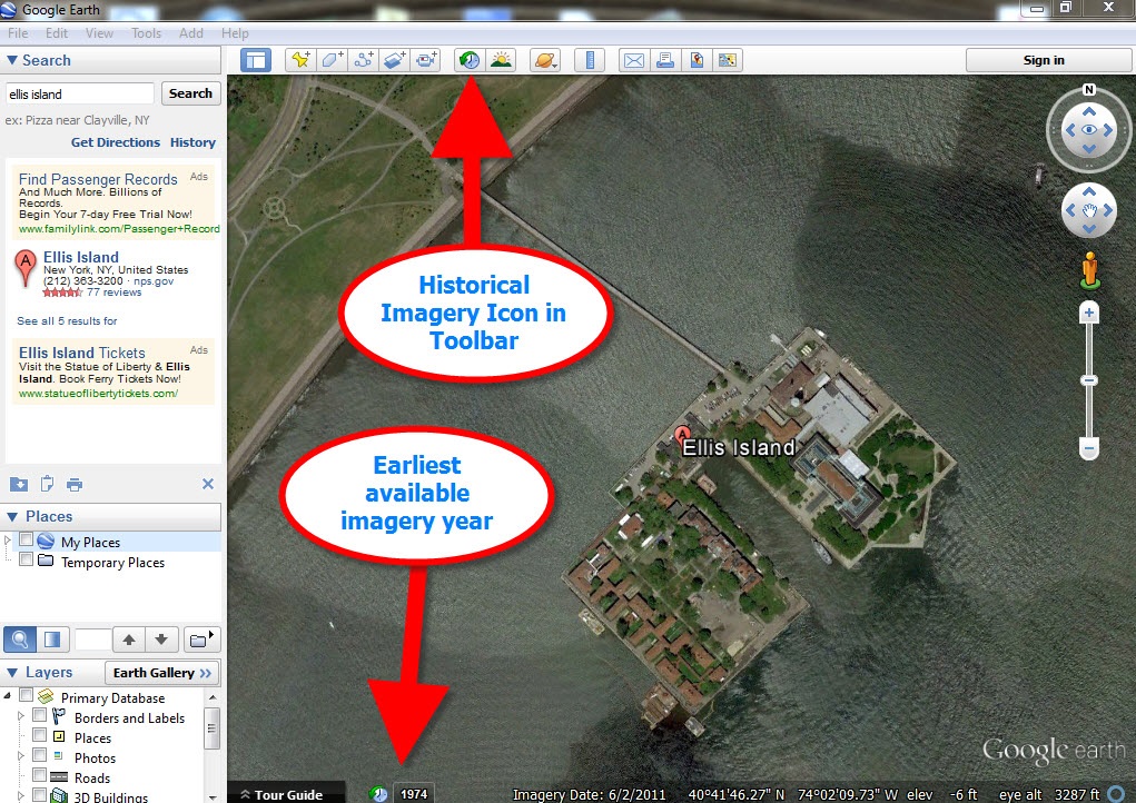
While this feature has just rolled out in Google Maps, and is not yet available in our beloved Google Earth, I predict this omission will not last long. You may have already noticed that as you zoom in closer to street level in Google Earth a small clock icon appears at the bottom of the screen indicating historical satellite imagery is available. Next to the icon a date now appears indicating the earliest available imagery. Click the Historical Imagery icon in Google Earth’s toolbar and a time slider indicating the years available will appear.
For most areas of the world this spans about as long as satellite imagery has been around. But in some key areas, such as London and parts of Europe, the slider goes back to the World War II era. Black and white aerial imagery of war torn areas are plainly visible. (If you have World War II veterans in your family tree, this is a feature you’ll want to explore.) It can only be a matter of time before this same Historical Imagery comes to Google Earth’s Street View.
More Ways to Explore and Time Travel Now
If you are intrigued by the idea of using this technology to simulate your own genealogical time travel experience, watch my free video called Google Earth for Genealogy. You’ll travel along with me as I uncover the secrets of a photograph taken just over one hundred years ago, pinpoint the location today, and then travel back in time to further explore my ancestor’s neighborhood. From there, the sky is the limit with Google Earth and Google Maps!
Gail Rogers in Ottawa, Ontario, Canada recently shared how my presentation on using Google Earth for genealogy helped her find her way to the site of an old family business–and the place where her ancestor died. She’s given me permission to share it with you. I hope you find it as inspiring as I do!
“Just last week, I received an 1879 death certificate for my great-great-great-grandmother. She ran The Castle Inn in Stafford, Staffordshire, England after the death of her husband in 1863. To my sorrow and horror, I learned that she hanged herself probably within the establishment where she also lived!
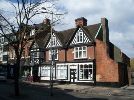
“When I shared this with a group of English and Australian cousins who are also researching this family, one of them sent me a link to a 1960s photo of The Castle Inn, shortly before its demolition:
“Then I remembered your presentation about pinpointing your ancestor’s home in San Francisco. I’ve had several “family history” maps with icons that I’ve been working on for the past five years at Google Maps, so I went to the one for my Staffordshire ancestors, clicked on my icon for Eastgate Street in Stafford, and used the Street View to wander down the street, looking for the outline of the roofs, as you did with your old family photo. (You can view a video of my Google Earth for Genealogy class for free here on my website that demonstrates this technique.)
“I soon spotted the outline at the extreme left of the photo, “turned around” (virtually) and wham! There were the double Elizabethan-style timber-framed gables, just as they appeared in the older photo!”
Gail, I was so glad to read that this helped you. I’ve gotten so much great feedback on that particular example of how to use powerful Google Earth (and Google Maps) tools to find important family landmarks.
The presentation she’s talking about can be found in The Genealogist’s Google Toolbox Kit, a value bundle that includes my book The Genealogist’s Google Toolbox and Volumes I and II of Google Earth for Genealogy (on video CD). Even better, right now that kit is available for 20% off! The 2 discs are also available as a bundle on their own. And thanks, Gail, for sharing your success with us!
Google celebrated Earth Day by releasing Google Earth 7.1 and announcing some great new content! And there are three reasons you will want to make the upgrade:
1. New Hands-Free Navigation Technology
The big news with version 7.1 is Leap Motion support, a touch-free 3d technology that lets you “navigate Google earth with simple hand gestures.” The Leap Motion Controller ($79.99) will start shipping mid-July, so you’ve got some time to get to know Google Earth a little better before you start flying around in it like this:
You KNOW I have to get me some of that!
2. More 3D City Views There’s also exciting new 3D data in Google Earth, most notably for New York City. But there’s also more imagery for other cities around the world: Innsbruck, Austria; Dijon, France; Cagliari, Italy and the Spanish cities of San Sebastian, Santander, Pamplona, Manresa and Burgos. Other U.S. cities with 3D coverage include Miami, FL; Houston, TX; Orlando, FL; Encinitas, CA and Spokane, WA.
3. The Addition of the 50th Country to Google Maps’ popular Street View Feature
You can now view 50 countries buy lasix medication online with Google Maps’ popular Street View feature. The newest nations to be added are Hungary and Lesotho (a tiny country within South Africa), and there’s new or updated coverage for Poland, Romania, France, Italy, Russia, Singapore, Thailand and other locations worldwide. Google calls this “the largest single update of Street View imagery we’ve ever pushed, including new and updated imagery for nearly 350,000 miles of roads across 14 countries.”
Help for Using Google Earth for Genealogy
How can you access these fabulous features, both for fun virtual travel and for seriously fun genealogy research? Upload the latest version of Google Earth for free (for PC, Mac or Linux). Then check out my Google Earth for Genealogy 2-CD Bundle. There’s a reason is this one of my best-selling presentations: Google Earth is one of the best genealogy research tools around! In these CD presentations, I show you how to locate and map ancestral homesteads; use historical map overlays; identify where old photos were taken; create 3D models of ancestral locations; create custom family history tours and much more.
 If you wish to know the distance around the perimeter, click Distance. (You can measure individual distances, such as the width of the lot at the back, by only clicking on the points between which you want to measure.)
 More Genealogy Mapping Gems