Old maps are vitally important for genealogy because the characteristics of a location can change in many ways over time. Historic maps help us understand the world as it was at the time our ancestors lived.
Here is a short list of just a few of the things that may have changed:
Street addresses
roads
town names
county boundaries
waterways that may have been filled in or opened up
railway lines
In fact, the country itself where they lived may be a completely different country. For example, my German ancestors lived in Prussia in the 19th century. Today, that area is part of Poland. Therefore, all of the village names have been changed to Polish names.
The David Rumsey Map Collection is an excellent place to go to find maps of your ancestors homeland for free.
Watch the Map Search Video
I’m going to explain the 7 steps to finding the maps you need for your genealogy research at this wonderful website! I highly recommend that you watch the short video below to see it in action as you read. The player will stay with you as you scroll down the page.
Step 1: Go to the David Rumsey Map Collection Website
The first thing you need to do is go to the David Rumsey website here. You’ll be greeted on the home page with glorious historic maps. (Stay focused because it’s easy to get distracted by all the fascinating maps!)
Scroll down on the David Rumsey website home page.
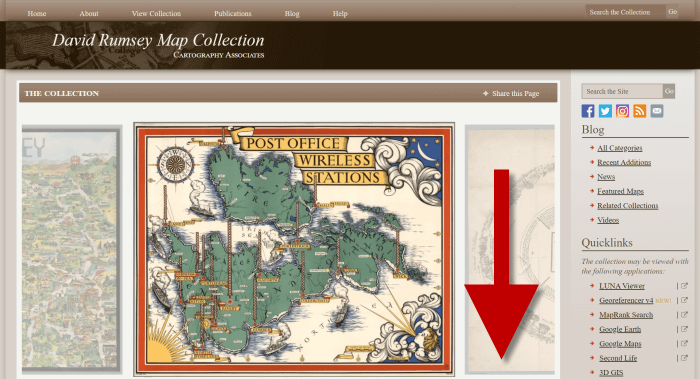
Step 2: Scroll Down to the Bottom of the David Rumsey Home Page
While you can search for a place name in the search box at the top of the page, there’s a better way to search. Scroll down the page until you get to Featured App: MapRank Search (it’s almost at the bottom.)
Step 3: Launch Map Rank Search
The Featured App – MapRank Search is the best place to search the website, but it’s easy to miss because it’s not at the top. So go ahead and click the Launch MapRank button in the upper corner of this section.
In the Featured App: MaprRank Search section click the Launch MapRank button
When you click the button it will open a new tab in your web browser which will take you to the Geographical Searching with MapRank Search page.
Quick Tip: The Fastest Way to MapRank Search
You can get there faster by going directly to https://rumsey.mapranksearch.com. I didn’t take you straight there from the beginning because I think it’s important to be aware of the home page and everything else it offers. However, today our focus is conducting the optimal search for old maps for you family history.
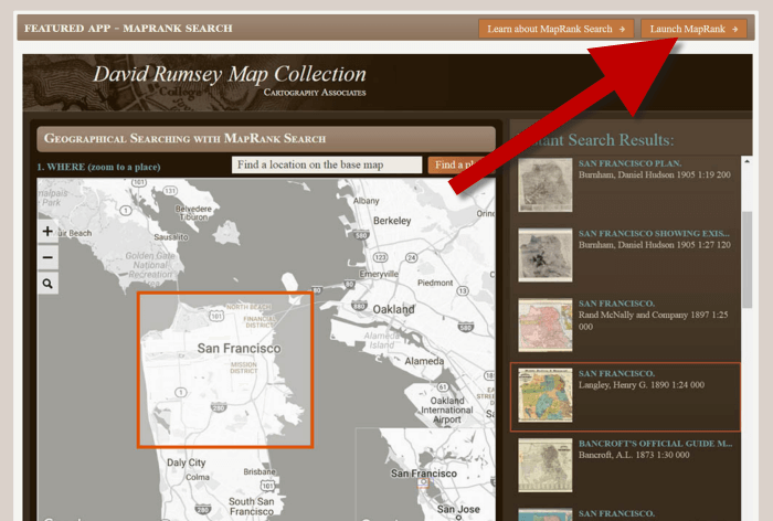
Step 4 Selecting the Map Time Frame
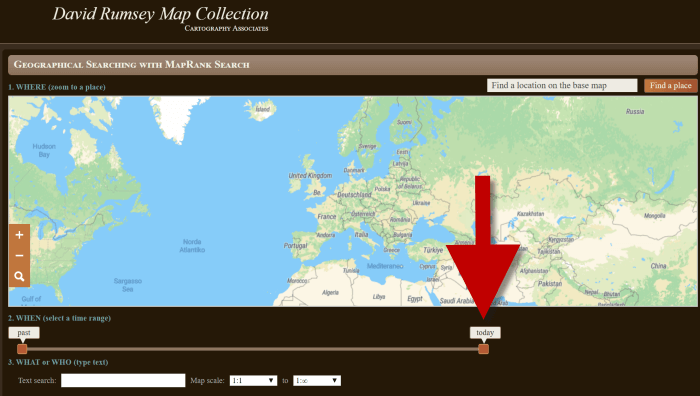
Here’s what the search page looks like.
The DavidRumsey.com search page
There are two very important features on this app page that will help you get the best results possible: the time slider and the location search box.
The time slider is located beneath the map:
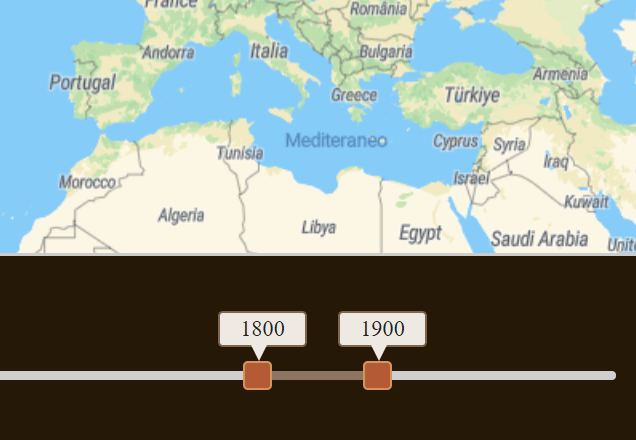
Time Slider for searching maps by time frame
It’s important to first select the time frame that you are searching because that will dictate the results you get when you search on the location name. (We’ll get to that in just a moment.)
There is a slider on each end of the timeline. Slide them to specify the desired time frame. In my example below, I’m looking for maps between 1800 and 1900.
Searching for maps between 1800 and 1900
As you move the sliders, you’ll notice that the maps in the right hand column will change. This is because only maps that fall within the range you select will be offered in the Instant Search Results column. But before we look at those, we need to type in a location in the next step.
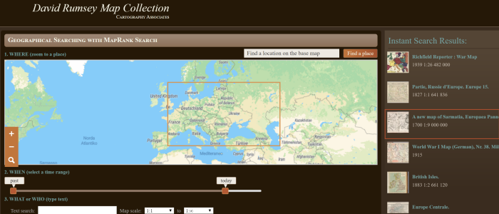
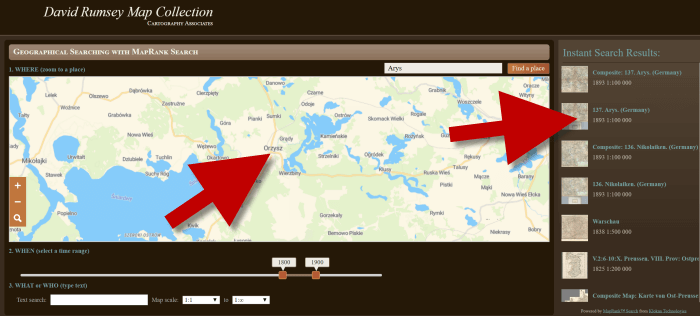
Step 5: Selecting the Location
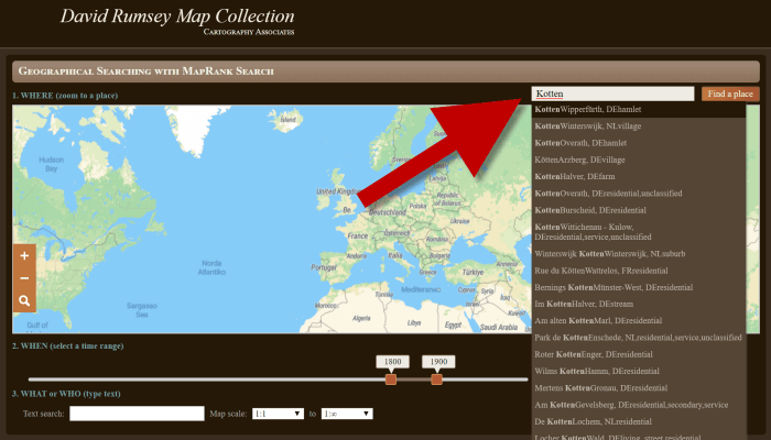
With your time frame selected, now you’re ready to type the location in the search box.
As you type, the app will make suggestions. But wait! Before you click the Find a Place button to run the search, look carefully at the list of suggested locations that may appear. Many locations names can be found in different areas. That is certainly the case with the name of the tiny village where my great grandfather was born: Kotten.
Type the location name to search the maps
In fact, the list doesn’t even include the Kotten I am looking for.
In cases like this, it is best to search a little more broadly. When Kotten was part of Prussia, it was located in Kreis Johannisburg so I could try searching for that. Even better might be to search for the largest city in the area since Kotten was such a tiny village. Arys was the largest city in the area.
Once you type in the name (and select from the suggestions if needed) click the Find a Place button just to the right of the search box.
Step 6: Analyze the Map Results
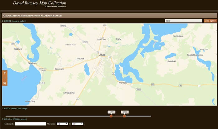
In my example of searching for the city of Arys (which is the name it was known by in the 19th century when it was part of East Prussia) the modern-day map displayed is actually Poland.
My search resulted in a map showing Orzysz, Poland
However, the David Rumsey website does a good job of cross-referencing the older German names (Arys) with the new Polish names (Orzysz). This is another reason why searching for a larger city works well. Larger cities are more likely to be in the David Rumsey system for cross-referencing, and of course they are easier to spot on the map. Generally speaking, the location you searched will be in the center of the display map.
Quick Tip: Verifying Location Names
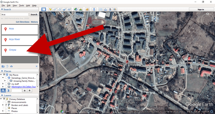
Another quick way to cross-reference location names (or verify your findings in David Rumsey) is by searching for the name in Google Earth. In the example below, I typed in the Prussian city of Arys. Google Earth will offer options if more than one matching result exists.
I was a bit surprised to see “Arys” as one of the three listed results since it is not called that today. When I clicked Arys it took me to the city of Arys in the Turkistan Region of Kazakhstan, far away from Poland! Clicking Orzysz in the results list took me to the area of Poland that was once East Prussia. This confirms the results I received at the David Rumsey website.
Now it’s time to review the map results listed in the Instant Search Results column on the right. Isn’t it fantastic that David Rumsey’s website not only presented me with the correct Polish location, but also maps published between 1800 and 1900 that include Arys? I think so!
Map results appear in the column on the right side of the page.
Click the map you think best suits your needs. The map will open in in a new tab in your web browser. (These browsers tabs provide a nice bread crumb trail for your searching activities.)
All of the source information about the historic map that you chose will appear in the column on the left. (See the image in Step 7.) If you decide to use this map you’ll definitely want to accurately cite the source. Learn more about the importance of source citations here.
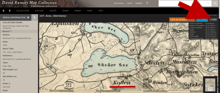
Step 7: Export the Map
I was delighted to find the village of Kotten on this map of Arys published by Reichsamt fur Landesaufnahme in 1893!
When you find a map that you would like to use for your family history research, export it to your computer. To do this, click Export in the upper right corner of the map and select the desired size. You can select a size ranging from Small Thumbnail to Extra Extra Large. Keep in mind that the larger the size, the more clarity you will have as you zoom in closer and closer. This is very important if you plan on using the map in an overlay in Google Earth. You can learn how to create your own map overlays in my video tutorial series on using Google Earth for genealogy available here, and in my book The Genealogist’s Google Toolbox.
Click “Export” to save the map to your computer.
Be patient while downloading to your computer because it can take several moments to export a large map. The saved file will probably be zipped. To unzip it, on a PC right-click and select ExtractAll from the pop-up menu. This creates an open version of the folder containing the map.
Get Started Finding Your Ancestral Locations in Old Maps
With this step-by-step process you are now ready to explore any given ancestor’s world through the rich details of historic maps. I can’t wait to hear what you discover! Please be sure to leave a comment below. And if you found this tutorial helpful, will you please share it with your friends on social media so we can help even more people find the homes of their ancestors? Thank you!
You can now see New York City street views from the late 1800s and early 1900s as Google Earth street views. Take a virtual visit to the Big Apple as it was 100 years ago! Or travel back even further in time to an 1836 map of NYC conveniently overlaid on a modern Google Earth view. These are just two of the many ways to use Google Earth for genealogy—and for fun.
Vintage New York City Street Views on Google Earth
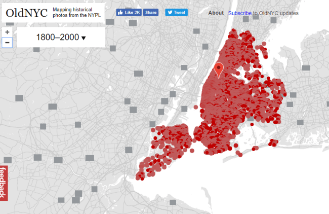
Over 80,000 original photos from the late 1800s and early 1900s have been mapped into Google Earth to provide what’s essentially a Google Street View map of old New York City!
As you can see from this overview map (below), the old photos are concentrated in the areas of Staten Island, Brooklyn, Queens and Lower and Upper Manhattan. Dots represents historic photos that have been overlaid on Google Earth’s modern map (satellite view is also available).
Old NYC
You can zoom in to click on individual dots, which will bring up one or more individual photos of certain neighborhoods or street fronts:
Select the photos that match up best with your family history interests, such as a shot of your family’s old store front or apartment building. Or choose images that represent the time period in which your relatives lived in the area, so you can get a flavor of what their neighborhood would have looked like. (Click here for some ideas about where to look for your family’s exact address during the late 1800s or early 1900s.)
According to this article at BusinessInsider.com, a developer Dan Vanderkam worked with the New York Public Library to plot all the photos onto Google Earth. (A hat-tip to Genealogy Gems listener and reader Jennifer, who sent me this article because she knows how much I love old maps and data visualization!)
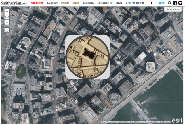
Another Old NYC Street View: 1836 Map
While we’re on the subject, I also want to mention another cool tool for visualizing old NYC street views. At the Smithsonian.com, there’s a cool historic map overlay of an 1836 New York City map in Google Earth. Use the scrolling and zooming tools to explore the parts of NYC that were already settled–and to compare them to what’s there today. You can also swap views to see the 1836 map with just a little round window of the modern streets.
The accompanying article quotes famous map collector David Rumsey about the 1836 map, which is his. He describes how you can see that much of the topography of Manhattan has changed over the years—did you know Manhattan used to be hilly? And I love how he calls out artistic features on the old map, too.
Smithsonian NYC street view 1836
Unfortunately, the old map doesn’t show much in the way of residents’ property lines or buildings. But you can clearly see the street layouts and where the parks and hills were. Comparing these areas with Google Earth’s street view today can help you better understand what things looked like in a much older version of one of the world’s great cities.
Use Google Earth for Your Genealogy
There are so many ways to use Google Earth for genealogy! My free video class will get you started. After a quick tutorial on downloading and navigating Google Earth, see how to utilize its powerful tools to identify an old family photo, map out addresses that may have changed and even plot an old ancestral homestead.
Old maps are an essential tool for discovering more about your family’s history. If you have exhausted more traditional sources, here are three places to find maps that may surprise you.
#1 Surprising Finds within the David Rumsey Map Collection
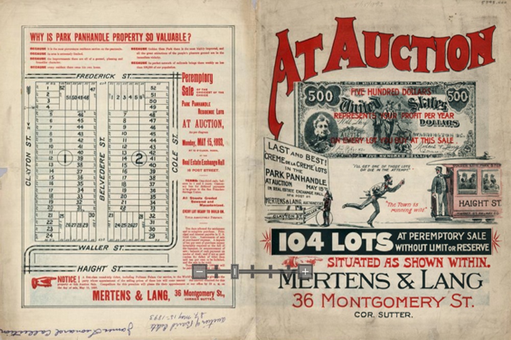
You’re probably aware that the David Rumsey map collection website is a terrific source for old maps. But you may be surprised by the variety of maps, some which you likely don’t come across every day. Here’s a fun little tactic I took today to see what it may hold in store beyond typical maps. A search of the word neighborhood reveals that their holdings go well beyond traditional maps. Here’s an example from San Francisco showing a neighborhood in its infancy:
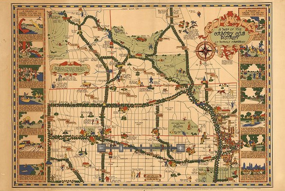
And the image below depicts the Country Club district of Kansas City in the 1930s. If your family lived there at that time, this is a real gem.
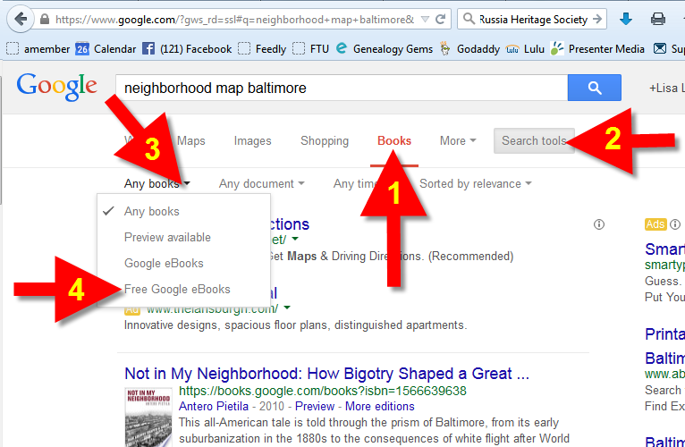
If you think Google Books is just books, think again. Historic maps, often unique and very specific, can often be found within those digitized pages. Try running a Google search such as: neighborhood map baltimore.
Click the MORE menu and select BOOKS. Then click the SEARCH TOOLS button at the top of the results list, and from the drop down menu select ANY BOOKS and then click FREE GOOGLE BOOKS:
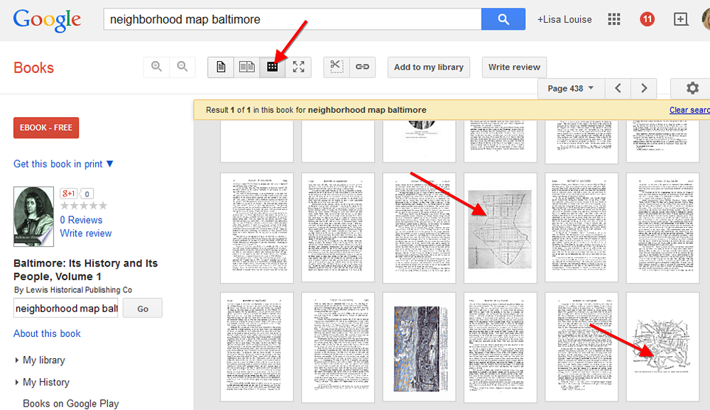
Select a book that looks promising. Then rather than reading through the pages or scanning the index, save loads of time by clicking the thumbnail view button at the top of the book. This way you can do a quick visual scan for pages featuring maps!
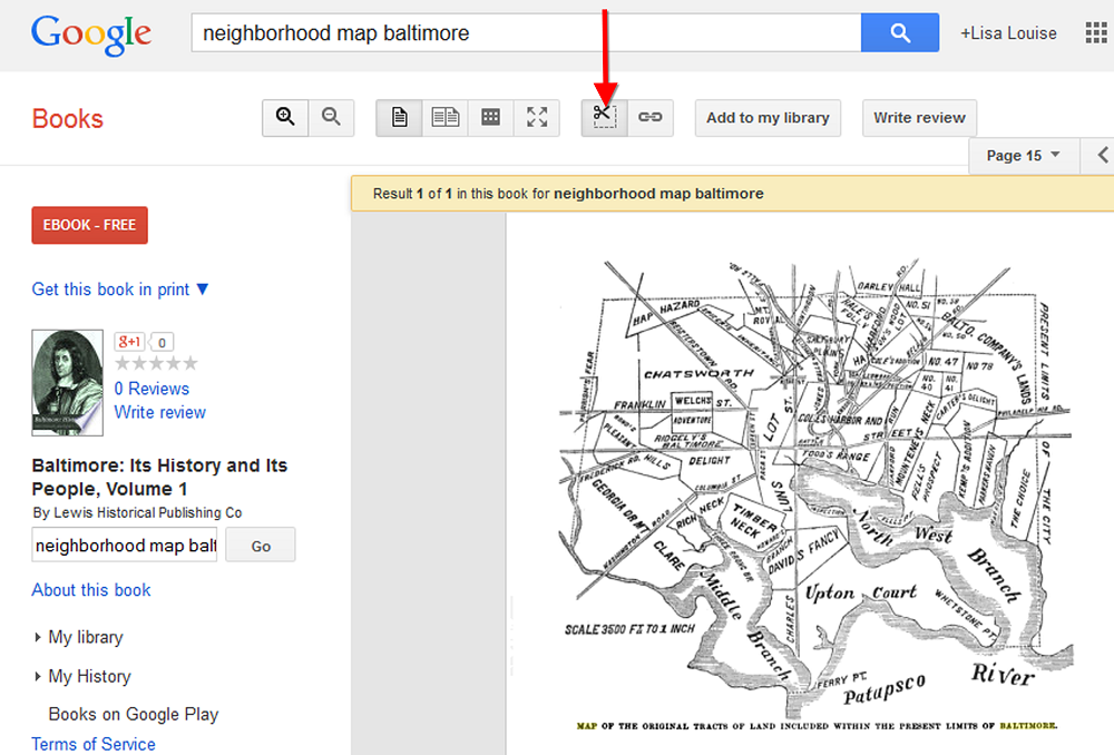
When you find a page featuring a map, click it display it on a single page. You can now use the clipper tool built right in to Google Books to clip an image of the map. Other options include using Evernote (free) or Snagit ($).
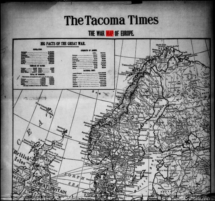
Like Google Books, the digitized pages housed at the Chronicling America website contain much more than just text. Old newspapers printed maps to help readers understand current events like the progress of war or the effect of a natural disaster. This map from The Tacoma Times in 1914 shows a map of Europe and several quick facts about the “Great War,” World War I:
The Tacoma Times, August 22, 1914. Image from Chronicling America. Click on image to visit webpage.
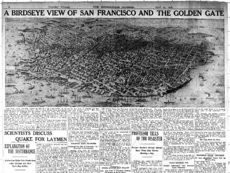
Here’s one more example below. A search for “San Francisco earthquake” at Chronicling America brought up this bird’s eye view of San Francisco at the time of the major 1906 earthquake. Articles below the map explain what you’re seeing:
The Minneapolis Journal, April 19, 1906. Image at Chronicling America; click on image to see it there.
Google celebrated Earth Day by releasing Google Earth 7.1 and announcing some great new content! And there are three reasons you will want to make the upgrade:
1. New Hands-Free Navigation Technology
The big news with version 7.1 is Leap Motion support, a touch-free 3d technology that lets you “navigate Google earth with simple hand gestures.” The Leap Motion Controller ($79.99) will start shipping mid-July, so you’ve got some time to get to know Google Earth a little better before you start flying around in it like this:
You KNOW I have to get me some of that!
2. More 3D City Views There’s also exciting new 3D data in Google Earth, most notably for New York City. But there’s also more imagery for other cities around the world: Innsbruck, Austria; Dijon, France; Cagliari, Italy and the Spanish cities of San Sebastian, Santander, Pamplona, Manresa and Burgos. Other U.S. cities with 3D coverage include Miami, FL; Houston, TX; Orlando, FL; Encinitas, CA and Spokane, WA.
3. The Addition of the 50th Country to Google Maps’ popular Street View Feature
You can now view 50 countries buy lasix medication online with Google Maps’ popular Street View feature. The newest nations to be added are Hungary and Lesotho (a tiny country within South Africa), and there’s new or updated coverage for Poland, Romania, France, Italy, Russia, Singapore, Thailand and other locations worldwide. Google calls this “the largest single update of Street View imagery we’ve ever pushed, including new and updated imagery for nearly 350,000 miles of roads across 14 countries.”
Help for Using Google Earth for Genealogy
How can you access these fabulous features, both for fun virtual travel and for seriously fun genealogy research? Upload the latest version of Google Earth for free (for PC, Mac or Linux). Then check out my Google Earth for Genealogy 2-CD Bundle. There’s a reason is this one of my best-selling presentations: Google Earth is one of the best genealogy research tools around! In these CD presentations, I show you how to locate and map ancestral homesteads; use historical map overlays; identify where old photos were taken; create 3D models of ancestral locations; create custom family history tours and much more.