by Lisa Cooke | Jun 12, 2014 | 01 What's New, Google, Maps, Military
 World War II started a revolution in map-making. It didn’t just change maps, but it also changed how the world looked at maps.
Maps suddenly became very interesting to everyone. Not just war strategists and troops but all those left behind on the home front. This interest was fueled even more by a revolution in how maps were made–a revolution that anticipated the information-sharing power of Google Earth.
“War has perennially driven interest in geography, but World War II was different,” reports this article in New Republic. “The urgency of the war, coupled with the advent of aviation, fueled the demand not just for more but different maps, particularly ones that could explain why President Roosevelt was stationing troops in Iceland, or sending fleets to the Indian Ocean.”
The story focuses on artist Richard Edes Harrison, whose World War II maps portrayed theaters of war with vivid clarity. He used the artist’s tools of shading, color and perspective to create maps “that could be intuitively understood by readers of widely varied levels of literacy and sophistication.” His “colorful and sometimes disorienting pictures (not quite maps)…emphasized relationships between cities, nations, and continents at the heart of the war. These maps were published in Fortune, then issued in an atlas that became an instant bestseller in 1944.”
After reading the article I ran a quick check of Google Books, one of my favorite go-to genealogy resources online, on “Richard Edes Harrison:. Sure enough, Google Books has a fully digitized copy of Life magazine (Feb 28, 1944) which includes the article “Perspective Maps: Harrison Atlas Gives Fresh New Look to Old World.” It’s not only chock full of his color maps, but includes a detailed section on how he drew his maps. You can see it here
What really caught my attention was the article’s explanation of how these World War II maps anticipated the information-sharing power of Google Earth. Google Earth shows us the terrain as well as geographic boundaries. That helps us understand things like movements of troops–or movements of ancestors.
As genealogists, we can learn so much by studying maps–particularly the powerful ones on Google Earth. Genealogy Gems Premium Members have access to my series of videos on Geographic Genealogy, including:
- Google Earth for Genealogy
- Time Travel with Google Earth
- 5 Ways to Enhance Your Research with Old Maps (brand new full hour class – retail value alone $39.95)
P remium Membership is a bargain at only $29.95 for an entire
  year’s access, plus right now you get the free bonus ebook Lisa Louise Cooke’s 84 Best Tips, Tricks & Tools from Family Tree Magazine.
Click here to learn more about Premium Membership.
by Lisa Cooke | May 21, 2013 | 01 What's New, FamilySearch, Inspiration, iPad, Maps, Technology
A new app for FamilySearch.org users lets you map your ancestors’ birthplaces. It retrieves information about your ancestors from your data at FamilySearch.org. It’s called Family Map and it looks like this:
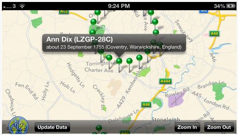
Family Map app for FamilySearch.org users.
While there are lots of maps online, it’s fun to see your relatives all mapped at once (with no extra effort from yourself). This tool is especially great for sharing your family history with relatives. They can see at a glance your family migration patterns, remark on the number of people who stayed in the old hometown (or didn’t) and put themselves in context.
Thanks to Devin Ashby at FamilySearch for tipping me off to this app. The app is FamilyMap – Scoutic and is available
on iTunes for $1.99.
by Lisa Cooke | May 8, 2013 | 01 What's New, Maps
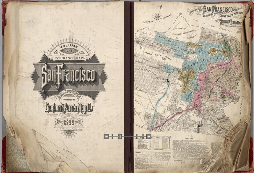
Opening pages of rare 1905 Sanborn Map of San Francisco, showing city just before 1906 earthquake. Find the entire map book at the David Rumsey Historical Map Collection
Genealogists rely on historical maps to help us navigate the geography of our ancestors’ lives. One of the most important resources available online is the David Rumsey Map Collection. Well, Rumsey recently announced on his website that he will be making more than 38,000 of his historical maps–everything he’s currently got online–available at the Digital Public Library of America (DPLA).
I blogged recently about the DPLA, which aims to create an enormous, free digital library we can all access online. It will be great to have the Rumsey map collection searchable on the DPLA so we can search these maps while we look for any other sources on any particular location our ancestors lived. “Maps tell stories that complement texts, images, and other resources found in the growing DPLA library,” says Rumsey. “And the open content policies of my online library fit perfectly with DPLA’s mission to make cultural resources freely available to all.” He applauds what the DPLA is trying to accomplish and even encourages other collectors to donate content.
Rumsey has spent years collecting thousands of old maps and putting them online. Now he’s working to share them even more widely. His entire collection of about 150,000 maps will eventually be housed at Stanford University. Meanwhile, we can all enjoy the thousands of images we can search on his site or at the DPLA.
Google’s free program Google Earth includes nearly 150 historic maps in the Layers panel. You can also add historic maps downloaded from Rumsey’s site to Google Earth by using the Overlay feature. My video tutorial series called Google Earth for Genealogy will show you how. You can also get step-by-step instructions in my book The Genealogist’s Google Toolbox. Or get them all in a discounted bundle.
by | Oct 5, 2012 | 01 What's New
Old maps can tell us a lot more than just where our ancestors lived: They put events into geographic context, reveal surprising genealogical clues, and can be incorporated into Google Earth for analysis and storytelling.
It used to be pretty difficult to find old maps to use in your family history research, but it is a lot easier these days. Libraries and archives are digitizing them and putting them online. And in the newest episode (#92) of the Genealogy Gems Premium Podcast I’ll tell you about a terrific example of a website that has set the goal of have every image they possess (allowable by copyright) digitized and on their website by early 2013
Also in this episode I’m going to tell you about something pretty shocking that happened to me recently while speaking at an international genealogy conference. I was really taken by surprise, and received some unexpected questions. I will share those with you as well as some solid answers.
It’s another packed episode. If you are a member sign in now to start listening.

Not a Genealogy Gems Premium Member yet?
There’s never been a better time to join! You will get access to videos of my most popular classes, and as of today 92 Premium episodes providing hours of genealogical education and fun.
Click here to become a Member today
 World War II started a revolution in map-making. It didn’t just change maps, but it also changed how the world looked at maps.
 remium Membership is a bargain at only $29.95 for an entire
  year’s access, plus right now you get the free bonus ebook Lisa Louise Cooke’s 84 Best Tips, Tricks & Tools from Family Tree Magazine.


